Entertainment
Carol Kirkwood's Emotional Farewell on BBC Breakfast, Welcomes Matt Taylor
Carol Kirkwood fought back tears during her final BBC Breakfast appearance, receiving tributes and addressing her replacement Matt Taylor as she closed a 28-year chapter.
Politics
Trump Threatens NATO Exit as Iran Conflict Escalates, Starmer Defends Alliance
Donald Trump sparks NATO crisis by considering US withdrawal, calling it a 'paper tiger', while Keir Starmer defends the alliance. Meanwhile, Iran conflict intensifies with attacks on oil facilities and threats to UK targets.
Sports
Spain Manager De La Fuente Condemns Anti-Muslim Chants by Fans
Spain's football coach Luis de la Fuente has denounced xenophobic chants from fans during a friendly against Egypt, calling them intolerable ahead of the World Cup.
Crime
Teen Shot Twice by Police During Welfare Check After Allegedly Pulling Knife
A 19-year-old man is in critical condition after being shot twice by police during a welfare check in Brisbane, with the incident witnessed by his mother and now under investigation.
Business
Health
Weather
Carol Kirkwood Delivers Final BBC Forecast After 30 Years
Carol Kirkwood, the beloved BBC Breakfast weather presenter, has given her last forecast after nearly 30 years with the BBC. The 63-year-old announced her departure earlier this year, describing it as 'the right moment to step away'.
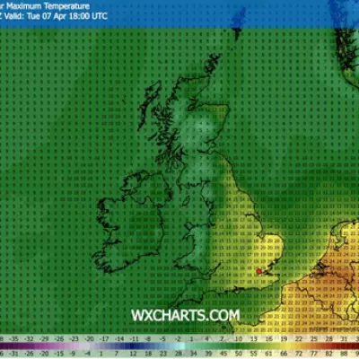
UK 20C Heatwave to Surpass Greece and Turkey Temperatures
Weather maps indicate a significant warm spell across the UK next week, with 11 regions forecast to exceed temperatures in Greece and Turkey, peaking at 20C.
Japan Warns of Ongoing Large Earthquake Risk After Tokyo Tremor
Japan's meteorological agency warns of potential aftershocks following a magnitude-5 earthquake near Tokyo, urging residents to remain vigilant for about a week.
Daylight Saving Ends: Australia's Clocks Go Back April 5
Daylight saving time ends in Australia on Sunday, April 5, 2025, with clocks moving back an hour in NSW, Victoria, SA, Tasmania, and ACT. Learn how it affects work, sleep, and daily routines.
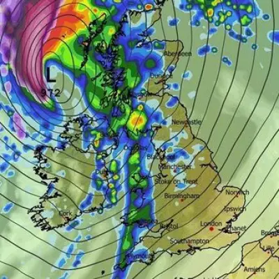
UK Faces 400-Mile Rain Wall and Easter Snowfall
Britain's Easter weekend forecast predicts a 400-mile wall of rain followed by snowfall, with unsettled conditions bringing heavy downpours and wintry showers across the nation.
Tech
Get Updates
Subscribe to our newsletter to receive the latest updates in your inbox!
We hate spammers and never send spam
Environment
Tuesday Test: Can You Answer These UK Sports Questions?
Test your knowledge of British sports with our Tuesday quiz featuring 100 questions about football, cricket, and rugby. Perfect for sports enthusiasts and trivia lovers.


