
Britain Swelters in Record April Heatwave as Temperatures Soar to 26C
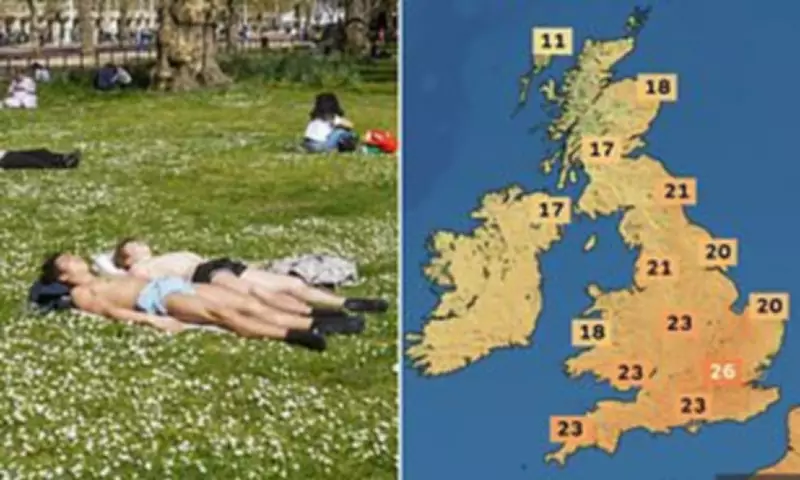
Britain basked in the hottest April 7 on record yesterday, with temperatures soaring to unprecedented levels for early spring. The mercury is set to climb even higher today, potentially eclipsing Tuesday as the warmest day of the year so far. Forecasters are predicting temperatures could reach a scorching 26 degrees Celsius in parts of the country, marking a significant spike in the seasonal warmth.
Record-Breaking Temperatures Across the Nation
The island of Anglesey in Wales recorded the highest temperature yesterday, with a reading of 24.8C in Mona. However, today's hottest spots are expected to shift to central and south-east England, as revealed by the latest weather maps. The Met Office confirmed that north-west Wales experienced the highest temperatures in the UK yesterday, noting that this was the warmest 7th April on record and the highest temperature of 2026 so far.
Met Office chief forecaster Paul Gundersen explained, 'We're seeing a brief but notable spell of very warm weather for early April, with temperatures more typically associated with late spring or early summer. This could be the warmest spell at this point in April since 2020, a year many will remember because of the Covid-19 lockdown.'

Pollen Bomb Warning and Public Enjoyment
Alongside the heat, forecasters have issued a warning about a 'pollen bomb', as tree pollen levels soar across much of the country. This could exacerbate allergies for many residents during this warm spell. Despite this, the timing of the warmth has been fortuitous for some, coinciding with school Easter holidays, leading families to flock to beaches and parks to enjoy the sunshine.
In Brighton, council leader Bella Sankey remarked, 'There really is no place like Brighton when the sun is shining. We're definitely seeing people keen to take advantage of the sunshine today, not just on the beach, but also visiting our seafront cafes and bars, or enjoying a walk along the prom.' Similar scenes were reported in Weymouth and Bournemouth, where councils noted increased visitor numbers enjoying the coastal amenities.
Short-Lived Warmth and Upcoming Changes
However, this warmth is expected to be short-lived. The Met Office has warned of a 'big change' on Thursday, with temperatures predicted to drop significantly to between 10C and 13C. A spokesperson stated, 'It's all purely down to wind direction at this time of year. For the next couple of days, we're dragging in that warm, southerly wind, which allows temperatures to reach the mid-20s. As we go into Thursday, temperatures will return to normal for the time of year, with more changeable weather including rain and showers.'
In some areas, daytime temperatures could fall by around 10C between Wednesday and Thursday. Over the weekend, temperatures are forecast to hover around 10C in the north and 14C in the south, marking a stark contrast to the current heatwave.
Context and Safety Reminders
This warmer spell follows in the wake of Storm Dave, which caused widespread damage and disruption over the Easter weekend with 70mph winds battering parts of northern England, Scotland, and Wales. As people enjoy the sun, authorities are urging caution, particularly regarding water safety. A spokesperson for Bournemouth, Christchurch and Poole Council reminded beachgoers to follow RNLI advice and noted that disposable BBQs are only permitted on the beach between 6pm and 10.30pm.
Overall, while Britain enjoys this brief respite of summer-like weather, residents are advised to make the most of it before cooler, more unsettled conditions return later this week.


