Queensland Confronts Historic Category 5 Cyclone Threat as Narelle Intensifies
Australia's Queensland region is bracing for what could become the most severe tropical cyclone in living memory, with Storm Narelle rapidly intensifying into a catastrophic category 5 system. Prime Minister Anthony Albanese has labelled the approaching weather event as potentially "very dangerous" for both Queensland and the Northern Territory, urging immediate preparedness across affected communities.
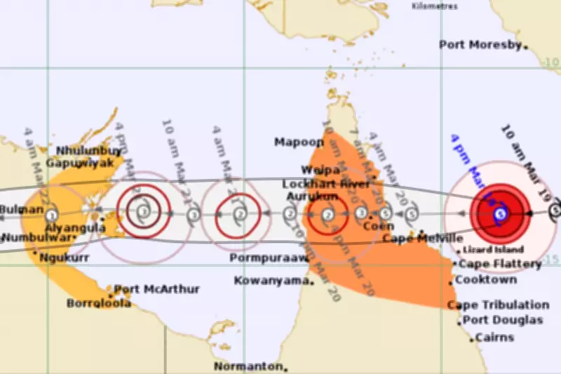
Unprecedented Landfall Expected with Destructive Winds
The Bureau of Meteorology forecasts that Cyclone Narelle will make landfall on Friday near the remote town of Coen on Cape York Peninsula, bringing wind gusts of up to 300kmph near the eye of the storm. Meteorologist Sue Oates confirmed that destructive winds extending from the intense core could reach 200 to 250kmph, creating life-threatening conditions across the region.
If Narelle crosses the coastline at category 5 strength, it will mark the first such system to strike that stretch of Queensland coast in over a century. Historical records indicate this would be only the fourth category 5 cyclone to cross the Queensland coastline in the past fifty years, underscoring the exceptional nature of this weather emergency.

Emergency Response Mobilised Across Multiple Regions
Queensland Premier David Crisafulli has confirmed that emergency services resources are being deployed throughout the region, with residents urged to use available time for preparation or evacuation. "This may be the biggest system that many people have seen in living memory, and that's why we're asking people to prepare as we have," Crisafulli stated during emergency briefings.
Police disaster coordinator Chris Stream issued stark warnings about the cyclone's lethal potential, emphasising that flying debris propelled at speeds exceeding 100kmph could prove fatal. "This is not the opportunity for you to be outside during the cyclone, getting that TikTok moment," Stream cautioned, urging residents to remain indoors throughout the storm's passage.
Geographic Vulnerabilities and Extended Impact Zones
Due to Cape York Peninsula's narrow width, authorities warn that destructive winds could reach communities well inland even as the system weakens after landfall. The cyclone formed on Tuesday evening south of the Solomon Islands and had already intensified to category 3 strength by Wednesday afternoon, demonstrating rapid development that concerns meteorologists.
Following its initial impact on Queensland, Cyclone Narelle is forecast to re-intensify as it tracks west across the Gulf of Carpentaria, potentially reaching severe tropical cyclone strength again before striking the eastern Northern Territory over the weekend. The Bureau of Meteorology has issued warnings for gales, destructive winds, and flash flooding in the Port McArthur and Nhulunbuy regions from Saturday onward.
Evacuations Underway for Vulnerable Populations
Targeted evacuations have already commenced, with vulnerable residents including those requiring dialysis treatment and pregnant women being flown out of the highest-risk areas. The luxury resort on Lizard Island has been evacuated, though eight essential staff remain at the Australian Museum coral research station under a comprehensive cyclone management plan.
Prime Minister Albanese confirmed that federal resources stand ready to assist, stating, "The Commonwealth stands ready to provide whatever assistance is required" as the emergency develops. This support becomes particularly crucial as parts of the Northern Territory, including Katherine and Daly River, continue recovery operations from recent flooding events.
Understanding Category 5 Cyclone Classification
Category 5 cyclones represent the most severe classification in Australia's tropical cyclone rating system, characterised by winds exceeding 200kmph and the potential for widespread destruction of buildings and vegetation. It is important to note that cyclone categories do not account for additional hazards including flooding or storm surges, both of which present significant risks during Cyclone Narelle's approach.

Queensland authorities emphasise that heavy rainfall accompanying the cyclone creates heightened risks of flash flooding across coastal regions, compounding the dangers presented by extreme winds. Residents throughout the projected path are urged to follow all emergency directives and prepare for potentially extended periods without essential services.