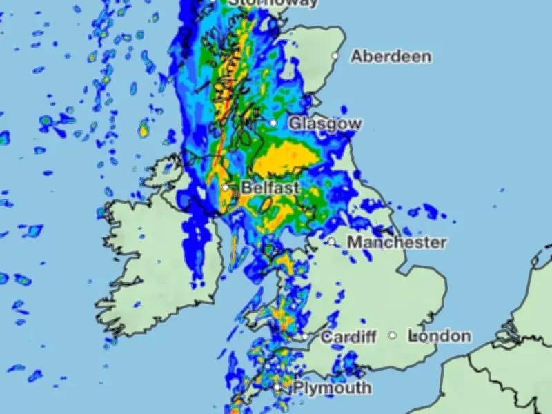
New weather maps from the Met Office show a mass of rain stretching 830 miles across the UK on Sunday, bringing up to 32mm per hour to the worst-affected areas and prompting an amber flood alert for the Essex coast.
The latest charts from the UK's national weather forecaster capture a low-pressure system moving across all four home nations. The showers are set to take shape overnight before making landfall in southwest England and Wales, where output will be a gentle 5mm per hour.
They will gather strength throughout the day and eventually unleash between 16mm and 32mm (0.6 and 1.25 inches) per hour for up to six hours in the worst-affected areas. Typically, affected cities and towns such as Belfast and Liverpool see around 75mm of rainfall in a standard September, making Sunday's downpours significant.
Rainfall timeline and affected areas
The Met Office charts show the first signs of rain spattering over parts of South Wales and Cornwall from around 3am on Sunday, with showers moving up over Wales in the following hours to 7.15am. They will remain calm on the Welsh coast as a much heavier band of rain moves up through St George's Channel and into the Irish Sea.
As the rain moves north, it will engulf Northern Ireland, leaving no county untouched as it pelts the home nation with between 0.5mm and 30mm from 7am to 2.15pm on Sunday. The maps show the same system landing in Scotland at around 10am, with up to 16mm of rain per hour settling on the southwest coast around Drummore and its surrounds. At this point, the rainy mass will have grown to cover nearly the entire length of the UK, 830 miles from Land's End in Cornwall to Stornoway in Scotland.
Scotland and northern England hit hardest
The vast bulk of the system will take root in Scotland, with every major city at risk of heavy downpours. According to the charts, Edinburgh, Glasgow, Dumfries, Fort William, Aberdeen, Jedburgh and Dundee could all see rainfall totals of up to 32mm per hour at points throughout Sunday. The rain looks set to remain anchored to the region until 8pm on Sunday.
England and Wales will also see their fair share of the inclement weather. Cardiff, Swansea, Caernarfon, Pembroke and Newtown in Wales will all see rainy showers, as will Plymouth, Exeter, Bristol, Swindon and elsewhere in southwest England. London, Reading and other communities in the southeast look likely to see some rain, but in more gentle, periodic showers.
The vast majority of England's rain will likely fall over northern England, according to the Met Office maps, with heavy showers hitting Preston, Kendal, Darlington, Newcastle and other areas around the same time as Scotland.
Flood alert and longer-term outlook
The Environment Agency has issued an amber flood alert for the Essex coast from Clacton to St Peters Flat and the Colne and Blackwater estuaries. The alert states that flooding is possible before the rainy system arrives, between 11.45pm today and 1.45am on Sunday due to "overtopping and spray" on the coast.
According to the forecaster's long-range forecast, the picture for much of England will be changeable over the next few days, with a mix of high pressure and "settled conditions" meaning rain is less likely as the period continues the pattern established over summer to remain both drier and warmer than usual.
The forecast for October 1 to 10 states: "Higher pressure and more settled conditions look likely to build across the UK, however it remains finely balanced whether this will become focused across the north or south. Lower pressure and interludes of more changeable weather are likely at times, but again, there are mixed signals regarding where this is more likely. However, an overall drier period than average is expected, with shorter periods of rain or showers. Winds are also likely to be lighter than average overall, but shorter periods of strong winds remain likely at this time of year, particularly across the northwest. Temperatures are likely to remain warmer than average."