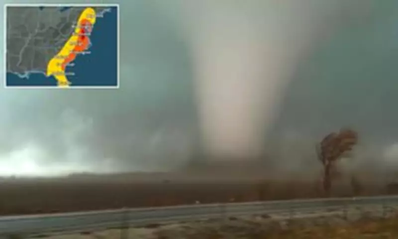
Massive Tornado Watch Issued for US East Coast as Dangerous Storm System Moves North
A massive tornado watch stretching more than 1,000 miles along the US East Coast was issued on Monday as a dangerous storm system moves northward. Meteorologists have warned that this sprawling outbreak could produce tornadoes, damaging winds, and large hail as the system sweeps through the Mid-Atlantic and Northeast regions.
Millions Under Alert Across Multiple States
More than 35 million people from the Florida Panhandle through Georgia, the Carolinas, Virginia, Maryland, Washington DC, Delaware, eastern Pennsylvania, New Jersey, and parts of New York are under tornado watches. The most dangerous period is expected from midday through early evening, with forecasters warning that the peak tornado threat in the Mid-Atlantic could occur between approximately 2pm and 7pm ET.
One of the largest watches spans dozens of counties in eastern Virginia, southeast Maryland, and northeastern North Carolina, remaining in effect until about 7pm ET. Other watches extend across parts of central North Carolina and coastal areas of the Southeast, while another covers a large portion of Pennsylvania, Delaware, and New Jersey.

Storm Intensification and Geographic Impact
Forecasters say the storms could rapidly intensify as warm, unstable air collides with a powerful weather system moving across the region. Residents across the watch area are being urged to closely monitor alerts and have multiple ways to receive warnings as the storms develop.
In Washington DC, Mayor Muriel Bowser is urging residents to prepare for severe weather expected to impact the city on Monday afternoon. At the mayor’s direction, the DC Homeland Security and Emergency Management Agency has activated the District’s Emergency Operations Center to monitor conditions and coordinate response efforts.
The storm system is already impacting communities across the Mid-Atlantic and Southeast, with tornado watches issued for more than 50 counties in Virginia alone. Areas under the watch include major population centers such as Norfolk, Virginia Beach, Newport News, and Chesapeake, along with smaller coastal communities stretching along the Chesapeake Bay and Virginia’s Eastern Shore.
Coastal and Inland Threats
Counties in southeastern Maryland, including Dorchester, Somerset, Wicomico, and Worcester, are also included in the watch area. Farther south, tornado watches extend across large parts of North Carolina, including counties such as Halifax, Wilson, Edgecombe, and Wayne.
Meteorologists say the threat is not limited to land areas, as tornado watches also cover several adjacent coastal waters, including portions of the Chesapeake Bay, the York River, and the James River, where strong thunderstorms could generate waterspouts or severe wind gusts.
Additional watches across coastal Florida and southern Georgia include counties such as Duval, Nassau, and St Johns in Florida and Camden and Glynn in Georgia. Storm Prediction Center officials said the wide geographic footprint reflects the strength and scale of the storm system sweeping northward along the East Coast.
Specific Regional Impacts and Warnings
In Pennsylvania, tornado watches extend across central counties, including Dauphin, Lancaster, Lebanon, and York, putting cities such as Harrisburg and Lancaster under alert until around 7pm ET. New Jersey counties, including Atlantic, Burlington, Camden, Gloucester, Ocean, and Monmouth, are also under the same watch, along with Delaware counties such as New Castle, Kent, and Sussex.
Forecasters warned the greatest risk will occur during the late afternoon as storms intensify and move northeast. The unstable air mass interacting with strong upper-level winds could allow rotating thunderstorms to form, which increases the chance of tornado development.
Safety Precautions and Expected Weakening
In addition to tornadoes, the storms could produce powerful wind gusts capable of knocking down trees and power lines. Emergency officials said residents should take the watches seriously and remain prepared to seek shelter quickly if warnings are issued.

Tornado watches mean conditions are favorable for tornadoes to form, while tornado warnings indicate a tornado has been spotted or detected on radar. The severe weather threat is expected to gradually weaken later Monday evening as the storm system pushes farther north and east.
However, forecasters cautioned that some strong thunderstorms may linger into the night before the system finally moves offshore. Until then, millions of residents along the East Coast remain under alert for rapidly changing and potentially dangerous weather conditions.