
Advanced weather forecasting models are predicting a dramatic shift from today's record warmth to a prolonged period of wintry conditions across the United Kingdom. Despite the Met Office declaring today the hottest day of the year so far, new data suggests an eight-day blizzard is on the horizon, with snow expected to impact major cities including London.
Extended Snowfall Timeline
According to the ECMWF weather model, the snowfall is projected to commence on March 13, with initial flurries forming over Scotland, northern England, and parts of the south-west. An Atlantic weather front is then forecast to sweep across the nation on March 14, bringing snow to Northern Ireland, southern Scotland, and northern England, while heavy rain affects much of England and Wales.
Northern Regions Bear Early Brunt
On March 15, further snowfall is anticipated, primarily confined to northern areas. Cities such as Glasgow, Edinburgh, and Newcastle could experience light flurries around 6am. The following days, March 16 and 17, are expected to see light snow over Scottish hills, with potential wintry showers extending to South Wales and the south-west of England by midday on March 17.

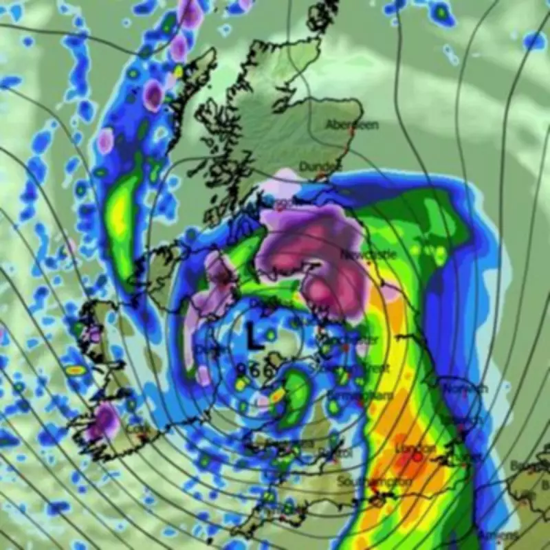
Snow Drifts Southwards
In a surprising turn, the snow is then predicted to drift eastwards, with maps for 6am on March 18 indicating snowfall impacting southern England and London. This would mark a significant extension of the cold spell into typically milder regions.
Temperature Plunge and Met Office Outlook
Temperatures are set to drop sharply throughout this period, occasionally falling below freezing. On March 18, northern England and Scotland could see lows of -2C, while even southern England might struggle with daytime temperatures barely reaching 4C. The Met Office has acknowledged the potential for "wintry hazards" later in March but does not anticipate "really cold" conditions developing.
The Met Office's forecast for March 19 to April 2 states: "The start of this period could see unsettled conditions quite widely across the UK, with spells of rain and strong winds affecting many areas at times. Then, whilst confidence in the details is low, there is the potential for weather patterns to become slower-moving by late March, with unsettled weather becoming more confined to parts of the south, as areas towards the north and northwest turn drier. Given this pattern, the chance of wintry hazards will increase compared to earlier in March. Overall, temperatures will probably end up near to average, but there is an increasing chance of below average temperatures towards the end of March, though at present, there is no strong sign for any really cold weather to develop."
Concluding the Cold Snap
The snowfall is expected to persist through March 19 and 20, affecting Northern Ireland, northern England, and Scotland, thereby completing eight consecutive days of wintry precipitation. This extended period of cold weather underscores the unpredictable nature of British springtime climate, with residents advised to prepare for potential disruptions and chilly conditions across the country.


