
Tropical Cyclone Narelle Intensifies on Path Towards Western Australia
The Bureau of Meteorology (BOM) has issued urgent warnings as Tropical Cyclone Narelle strengthens and tracks towards Western Australia, posing a significant threat to coastal regions including Perth. Current forecasts indicate the cyclone is intensifying into a severe category system, with potential for destructive winds, heavy rainfall, and dangerous storm surges along its projected path.
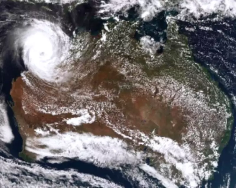
Tracking and Forecast Updates from the Bureau of Meteorology
According to the latest BOM tracking maps, Cyclone Narelle is moving steadily in a southwesterly direction, with models predicting it will approach the Western Australian coast in the coming days. The bureau has upgraded its alerts, emphasising the cyclone's rapid development and the likelihood of it reaching severe intensity. Residents in Perth and surrounding areas are advised to prepare for extreme weather conditions, including potential flooding and power outages.
Key details from the forecast include:

- Cyclone Narelle is expected to intensify to a severe category, with wind speeds potentially exceeding 150 kilometres per hour.
- The projected path shows the cyclone tracking close to Perth, raising concerns for urban and rural communities alike.
- BOM warnings highlight risks of heavy rainfall exceeding 200 millimetres in isolated areas, leading to flash flooding.
- Coastal regions may experience storm surges, with waves predicted to reach heights of up to 8 metres in exposed locations.
Preparations and Safety Measures for Affected Areas
Authorities in Western Australia are mobilising emergency services and urging residents to take immediate precautions. The State Emergency Service (SES) has activated response plans, including sandbag distribution and evacuation protocols for low-lying areas. Schools and public facilities in the cyclone's path may be closed as a precautionary measure, with updates provided through official channels.
Residents are advised to:
- Secure loose items around properties to prevent damage from high winds.
- Stock up on essential supplies, including food, water, and medications, for at least three days.
- Monitor BOM updates and local news for real-time information on the cyclone's movement and intensity.
- Follow evacuation orders if issued, moving to designated safe zones or shelters.
The impact of Cyclone Narelle is expected to be widespread, with disruptions to transport, including road closures and flight cancellations at Perth Airport. Power companies are on standby to address potential outages, while health services are preparing for increased demand due to weather-related injuries.
Historical Context and Climate Implications
Cyclone Narelle follows a pattern of increasing severe weather events in Western Australia, linked to broader climate trends. Historical data shows that cyclones of similar intensity have caused significant damage in the region, such as Cyclone Seroja in 2021, which devastated communities and infrastructure. Experts warn that rising sea temperatures may contribute to more frequent and intense cyclones in the future, underscoring the need for robust preparedness and adaptation strategies.
In summary, Tropical Cyclone Narelle represents a serious threat to Western Australia, with the Bureau of Meteorology closely monitoring its development. Residents should heed warnings and take proactive steps to ensure safety as the cyclone approaches.


