Mayor's Premonition Proves True as Category Five Cyclone Narelle Targets Queensland
Seven years after a devastating cyclone ravaged his remote community, Lockhart River mayor Wayne Butcher awoke with an unsettling intuition early Thursday morning. Despite calm conditions on Queensland's Cape York Peninsula, Mr Butcher sensed impending danger. "But you can feel it. Something's coming," he told AAP, his fears soon confirmed as authorities warned of Tropical Cyclone Narelle—the most powerful storm to threaten Cape York in over 125 years.
Historic Storm Threatens Catastrophic Damage
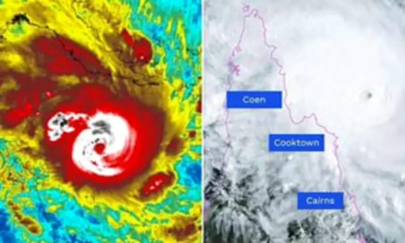
Tropical Cyclone Narelle is projected to make landfall near Coen, north of Cairns, around 7am AEST Friday as an extremely dangerous category five system. The cyclone will generate destructive wind gusts exceeding 250 kilometres per hour, with emergency services warning these winds could "blow apart sheds" and propel deadly debris at lethal speeds. Hundreds of residents have already been evacuated from vulnerable areas, with the Australian Defence Force placed on high alert.
"It's looking like it's gonna track the same way that bloody Cyclone Trev did. I couldn't sleep last night, I just had that funny feeling," Mr Butcher revealed, referencing Cyclone Trevor's catastrophic impact on March 19, 2019. That category four storm destroyed everything in its path when it struck Lockhart River. Now, exactly seven years later, the community faces Narelle—the first category five system to hit Cape York since Cyclone Mahina killed more than 300 people in March 1899.

Emergency Preparations and Evacuations Underway
Lockhart River has been included in an expanded cyclone warning zone extending south to Cape Tribulation. Authorities have implemented comprehensive emergency measures, including evacuating vulnerable residents, closing schools, and arranging final flights for tourists. Queensland Premier David Crisafulli offered a grim assessment: "I can't sugarcoat this, the damage will be widespread with a system of that size."
More than 100 emergency service personnel have been deployed northward, with police conducting door-to-door checks to ensure preparedness. The community faces particular challenges as Lockhart River lacks both a dedicated evacuation centre and an emergency operations centre to monitor the storm. Residents have been advised to relocate from timber and demountable homes into sturdier besser block structures.
"We kind of play everything by ear," Mr Butcher explained regarding their cyclone response strategy. "The phones will probably be out, so people will have to get the old two-way radios out of the cupboard and get ready for the clean-up."
Widespread Impacts Across Multiple Regions
The cyclone threatens to compound existing difficulties in far north Queensland, which is already recovering from flooding caused by consecutive tropical lows in recent months. Forecasters predict rainfall exceeding 500 millimetres across Cape York from Thursday onward, raising concerns about additional flooding.
Authorities have prepositioned shipping containers of essential supplies and emergency generators in anticipation of widespread power outages. After crossing Cape York, Cyclone Narelle is expected to impact the Northern Territory's Top End as a category three system on Saturday, potentially moving into Western Australia thereafter.
The Australian Army remains on standby to evacuate approximately 500 people from the Northern Territory community of Numbulwar in coming days—the same community evacuated during Cyclone Trevor's threat in 2019. A cyclone watch has been issued for parts of the Top End as preparations intensify across multiple jurisdictions.
Queensland disaster coordinator Assistant Commissioner Chris Stream emphasised the extreme danger: "The type of wind that is being predicted is the sort of thing that will blow apart sheds, that will blow caravans down roadways and create fields of airborne debris. Those types of objects being propelled at over 100km/h will have a fatal outcome."