
Weather charts indicate that snow will begin falling across northern parts of Scotland next Monday, with Arctic conditions spreading rapidly across the country. By Wednesday evening, snow is expected to reach the North East of England around Newcastle, and by Thursday morning, northern areas such as Manchester and Liverpool could see snow and icy conditions, potentially affecting voter turnout at polling stations for the general election.
Throughout Thursday, freezing weather will extend to Cardiff and the outskirts of London, as well as south coast areas including Southampton and Plymouth. By Friday, most of the UK is forecast to be blanketed in snow, with up to 17 inches accumulating between London and Southampton. The cold spell will persist into the weekend, with 16 inches of snow predicted just outside the capital on Sunday, December 14.
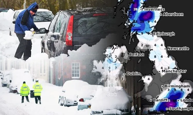
Temperatures are expected to hover just above zero on Monday but will plummet as the Arctic freeze takes hold, dropping to as low as -4°C in parts of Scotland. A brief respite on Tuesday will be followed by a sharp decline on Wednesday night, with temperatures falling to -8°C in Scotland and -4°C in the North West of England. Over the following 48 hours, temperatures will remain below zero, reaching -2°C around London, -4°C in the North West, and -6°C in the North East.

Met Office forecaster Helen Roberts noted that more freezing weather is approaching after weekend readings were “lower than anything seen so far at this end of the year.” Leon Brown, head of meteorological operations at the Weather Company, warned of a prolonged period of icy conditions, stating: “Thirty to 40 days with snow or ice disruption are expected this winter in Scotland and parts of northern England.”
The Met Office has issued a cold weather alert, with a 60 percent probability of severe cold weather in the coming days. A yellow alert is in effect for the southeast and East of England, urging preparedness, while green alerts cover southwest England, West Midlands, East Midlands, northwest England, northeast England, and Yorkshire and Humber. Freezing fog is also moving into the southeast, with forecasters warning of slower journey times.


