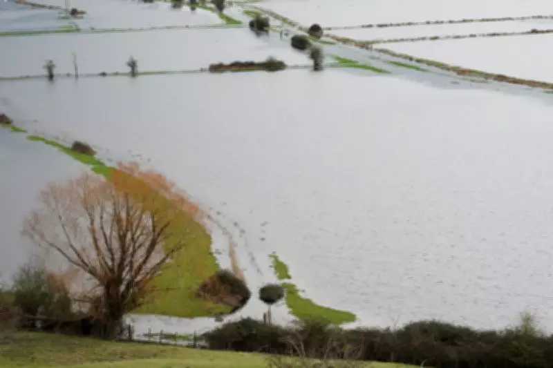
The Met Office has issued a stark warning that additional rainfall could significantly worsen flooding across south-west England in the aftermath of Storm Chandra. A yellow rain alert is now in effect for Cornwall, Devon, Dorset and Somerset from Monday afternoon through to Tuesday morning, targeting ground already saturated by recent severe weather.
Immediate Flood Risk to Properties and Transport
Meteorologist Jonathan Vautrey, speaking from the Met Office headquarters in Exeter, explained the developing situation. "During Monday itself, we are gradually going to be seeing a band of rain push its way northwards from the South West," he stated on Sunday night. "It'll take a little time, pushing into the Isles of Scilly and Cornwall as we head into the start of the afternoon, and then gradually heading towards Devon, Somerset and Dorset later in the day and into the overnight period."
Widespread rainfall of 10 to 20 millimetres is anticipated, but localised areas, particularly over hills and Dartmoor, could see deluges of 50 to 60 millimetres. "Because this area is so saturated, it does lead to the potential of exacerbating some of the flooding impacts that are already around," Mr Vautrey emphasised. He noted that fields remain waterlogged and rivers are running high, meaning any additional precipitation poses a direct threat.

Public Safety Warnings Issued
The forecaster has explicitly warned that people's property may be at risk of flooding. "Certainly, if your property is at the risk of flooding, then it's worth taking notes and then taking care of that," Mr Vautrey advised. Beyond property damage, the further rain on Monday is expected to cause significant travel disruption.
Roads could become treacherous, and public transport may be affected. There is a potential danger to life from fast-flowing or deep floodwater, with communities at risk of being cut off by flooded roads. This warning follows a January plagued by heavy rain, snow, and storms, which have left the region's infrastructure and landscape vulnerable.
Additional Weather Hazards: Ice and Snow
Compounding the flooding threat, a separate yellow ice alert has been issued for the south-west of England, parts of Hampshire, Wales, and Northern Ireland. This alert is in force from Sunday night through to Monday morning, with road users advised to beware of ice patches on untreated surfaces.
"We're going to see temperatures dropping away, and certainly likely to be seeing some frost developing," Mr Vautrey said. Northern Ireland could experience temperatures as low as minus 2C to minus 4C, leading to residual water freezing into hazardous icy stretches.
Meanwhile, more rain was expected across north-eastern areas of Scotland at the start of Monday, which would fall as snow over the mountains. For other regions further east, daytime temperatures on Monday were forecast to be around 5C to 9C, which is close to the seasonal average for early February.
Ongoing Flood Response and Major Incident
The Environment Agency reported that 57 flood warnings were in force across England, with the majority concentrated in Somerset, Dorset, and Wiltshire. A further 119 flood alerts were active nationwide. In Somerset, a major incident declared earlier in the week remains in place after approximately 50 properties were flooded by Storm Chandra.
On the Somerset Levels, ultra high-volume pumps continue to operate to remove flood water. Somerset Council has warned that with further rain expected, additional homes in the Moorland, Saltmoor, and Currymoor areas could be flooded. The Environment Agency stated that water levels in the River Tone have stabilised, and the Parrett flood relief channel has been opened to help drain excess water. Contingency pumps have also been installed at Aller Drove and Westonzoyland as part of the ongoing emergency response.