Storm Pedro Unleashes Wintry Conditions Across the UK
The United Kingdom is preparing for a period of severe winter weather as Storm Pedro sweeps across the nation, bringing with it a mix of rain, ice, and significant snowfall. The Met Office has issued multiple yellow weather warnings, highlighting risks of travel disruption and potential flooding in various regions.
Weather Warnings and Forecast Details
A yellow ice warning is currently active for much of Wales until 10am on Thursday, while a rain warning covers southern parts of England until 8am, with coastal areas expected to bear the brunt of the wet conditions. Forecasters have cautioned that heavy rain combined with snow could lead to localized flooding and significant travel issues.
Storm Pedro, named by Meteo France, is set to deliver widespread rainfall of 10 to 20mm, though areas near the south coast may experience up to 30mm. Dartmoor in Devon could see as much as 50mm of rain, exacerbating flood concerns.

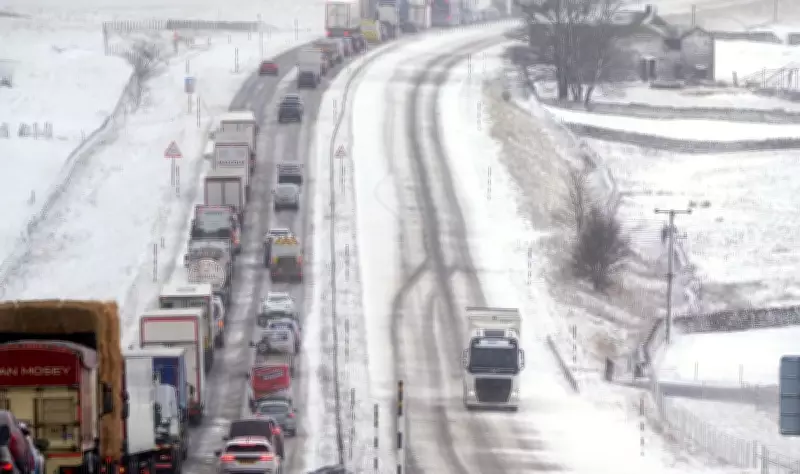
Snow Accumulations and Regional Impacts
The Met Office has also issued a yellow snow warning, noting the potential for rain and snow to affect Wales, central England, and the southern Pennines through Thursday morning. Snow accumulations are primarily expected on higher ground, with 2 to 5cm forecast widely above 150 to 200m. In mid- and south-east Wales, along with Herefordshire, Shropshire, and the southern Pennines, accumulations could reach 10 to 15cm above 250 to 300m. Lower elevations may see minor snow deposits of less than 2cm in the early hours.
Icy conditions are anticipated to cause further disruption in Wales and south-west England, increasing the risk of slips and falls on untreated surfaces. This follows a year marked by repeated flooding incidents across Britain, including recent disruptions from Storm Chandra.
Flood Alerts and Health Advisories
Currently, there are 74 flood warnings in place for England where flooding is expected, alongside 212 flood alerts indicating possible flooding. The UK Health Security Agency has issued cold weather alerts for several regions, including the East Midlands, West Midlands, North East, North West, South West, East of England, and Yorkshire and the Humber, effective from Tuesday evening until Friday evening.
These alerts warn of increased demand on healthcare services and heightened risks to vulnerable individuals due to the cold snap. Strong winds accompanying the wet weather may worsen conditions in some areas, according to the Met Office.
Expert Insights and Weekend Outlook
Deputy chief forecaster Steven Keates indicated that initial snow may affect the highest parts of southern England, such as Dartmoor, but the main snow threat lies across the Midlands and higher areas of Wales. Senior meteorologist Craig Snell provided a more optimistic outlook for the weekend, noting that winds should ease by late Thursday, with temperatures rising to the low-to-mid teens by Saturday, bringing milder conditions despite further spells of wind and rain.
As the UK navigates this wintry episode, residents are advised to stay updated on weather warnings and take necessary precautions to ensure safety during the disruptive conditions brought by Storm Pedro.