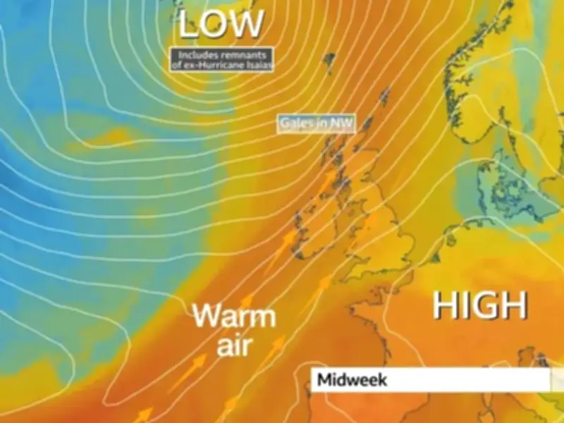
The UK is set for a burst of unusually warm October weather this week, with temperatures to climb above average and potentially reaching 23C before cooler conditions return.
The upward turn in temperatures is down to Hurricane Isaias, which hit the southern US on Saturday, leaving hundreds without power. Two people were killed in both Alabama and Florida after trees fell on homes.
In the UK, north-westerly winds brought some of the coldest weather of the autumn so far over the weekend. But remnants of the hurricane are now helping to bring a burst of warmer weather, with temperatures in parts of England potentially remaining as high as 18C on Monday night - close to the UK's October overnight record of 18.6C.
Daytime temperatures to rise above average
Daytime temperatures will also rise above average for the time of year across many parts of the UK, reaching between 14C and 19C compared with the mid-October average of around 12C to 16C. And temperatures could climb even further as the week goes on, with highs in the low 20s possible across southern and eastern England on Tuesday. Parts of East Anglia could reach around 23C.
But the unusually mild conditions will not bring clear skies, with much of the country facing cloud, rain and drizzle as warmer southerly winds move across the UK. Some brighter spells are still possible, particularly around north-east Scotland, east Wales, the West Midlands and the north coast of Northern Ireland.
Monday night is expected to remain particularly mild, with temperatures dropping only slightly before heavier rain develops and moves across the country into Tuesday morning. Conditions should brighten behind the rain, allowing temperatures to rise quickly in areas that see sunshine.
Midweek change brings wind and rain
Wednesday will get off to a cooler and clearer start for much of the country before another change arrives from the north-west. Strengthening winds and increasing cloud will accompany an area of low pressure moving between Britain and Iceland, which will carry some of the remnants of ex-Hurricane Isaias.
Warm and humid air will be pulled towards the UK ahead of a cold front, while north-west Scotland could also be hit by gales. The front will eventually push rain south-eastwards across Britain through Thursday and into the night.
However, south-east England could enjoy another burst of warmth before it arrives, with temperatures potentially topping 20C again on Thursday. By Friday, the brief spell of unusually warm October weather will begin to lose its grip as high pressure builds across the country.
Cooler conditions and drought concerns
Cooler air will bring temperatures back towards levels more typical for the time of year, while nights are also expected to turn noticeably chillier.
The return of high pressure is likely to keep rainfall limited - which will be little comfort to those monitoring the ongoing drought following a summer of extreme heat and little rain.
Despite rain being forecast at points this week, amounts are unlikely to be enough to make a significant difference in the worst-hit areas. Parts of Yorkshire have received less than 20% of their normal autumn rainfall so far.
Despite the sunny spells, The Met Office has pointed to the possibility of a wetter end to autumn and start to winter amid record El Niño conditions this year.