John Rocque's 1746 London Map Masterpiece Reborn in New Historical Book
In 1746, a groundbreaking map of London stunned viewers with its first-ever bird's-eye view of the capital. Now, 280 years later, John Rocque's masterpiece, An Exact Survey of the Cities of London and Westminster, and the Borough of Southwark, is being reproduced in a new book titled London in the 18th Century by Atlantic Publishing.
Pioneering Cartography and Historical Insight
Rocque, a French-born Huguenot cartographer, employed innovative triangulation techniques to create an accurate depiction of London and its rural surroundings. His work, spread across 24 sections, offers a unique glimpse into Georgian London, meticulously conserved and restored to pristine quality. The survey utilized basic tools like a perambulator, or surveyor's wheel, and a theodolite for measuring angles.
English Heritage historian Steven Brindle described the map as almost miraculous, noting Rocque worked with simple tools and two assistants. He explained that using a 66-foot chain and notebook, they measured fields and streets with remarkable accuracy, a process taking days for each area.

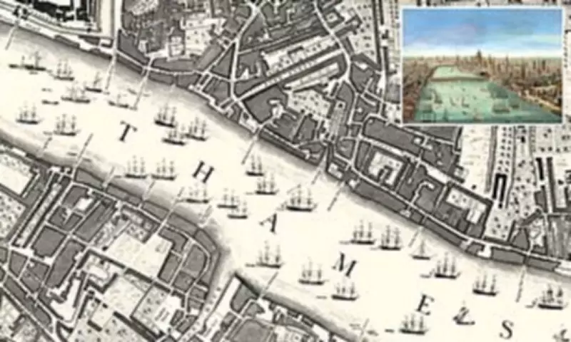
Exploring Georgian London's Landscape and Life
Author Crawford Snowdon delves into 1740s London, identifying surviving streets and buildings while tracing the routes of future major roads. At the time, London was a highly industrialized global trade hub, with tall ships crowding the River Thames. Key areas included:
- Hyde Park and Mayfair: Oxford Street appeared as Tiburn Road, and Marylebone Fields was scrubland plagued by duels and highwaymen.
- Spitalfields: Home to weavers, while Mile End was a small country town and Bethnal Green served as a rural retreat for gentlefolk.
- Whitechapel: The city's rubbish dump, and Bloomsbury featured fresh water springs feeding Holborn.
- South London: Characterized by fields, orchards, inns, farms, timber yards, and military camping grounds.
The map reveals a city of contrasts, with dense, insanitary alleys near wealthy merchants' homes and rural expanses like Vauxhall Gardens, a social gathering spot.
Historical Context and Legacy
Rocque's map predates landmarks like Tower Bridge by nearly 150 years and shows a London Bridge with 551 inhabitants when only two bridges spanned the Thames. Heads on spikes outside Temple Bar were a grim reminder of the era's justice. Trade in coal, wool, cloth, meat, and corn drew people to the capital, with outskirts extending to areas like Marylebone and Spitalfields.
Born in 1704, Rocque came from a Huguenot family that moved to England in 1709. He trained as a draughtsman, working on country mansion plans before spending 30 years as a respected land-surveyor and map-seller near Hyde Park Corner. In 1751, his map earned him the role of cartographer to Frederick, Prince of Wales. After his death in 1762, his widow continued the business for a decade.
Book Details and Publication
London in the 18th Century is based on a 64-page paperback from 1947 called London 200 Years Ago, released by the Daily Mail. Modern printing techniques have enabled this enhanced reproduction. The book includes histories and illustrations for each map section, capturing scenes like Covent Garden Market, St James's Park, and Soho Square. It will be released on Thursday, offering readers a vivid portal into 18th-century London.