The Met Office has issued a 35-hour yellow weather warning for thunderstorms and heavy rain across much of England and Wales, with up to 7.5mm per hour expected in some areas.
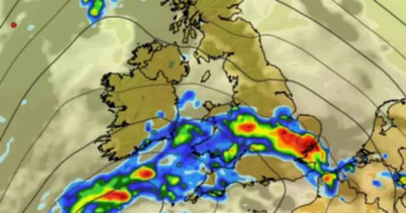
Weather maps produced by WXCharts show the regions most at risk, including large swathes of England and Wales. The national forecaster said a band of heavy showers and thunderstorms is expected to move across the country from early on Wednesday morning.
Two yellow alerts covering 35 hours
Two yellow weather alerts have been issued spanning a total of 35 hours over Wednesday and Thursday for regions including the Midlands, Manchester, Cheshire and north Wales. The first warning for thunderstorms runs from 3am to 10pm on Wednesday across much of England, including London and the south east, the Midlands, East Anglia, and parts of the north west, south west and eastern Wales.

A separate warning will come into effect on Thursday from 6am to 10pm across the East and West Midlands, south east, south west and north west of England, alongside Wales and Yorkshire.
Rainfall intensity and impact
New maps show heavy rain clouds hitting parts of southern and central England early on Wednesday morning, with downpours of up to 3mm per hour. By Thursday morning, the disruptive front is expected to have gained momentum, with up to 7.5mm falling on Wales and most of southern England.
The Met Office said warm and humid conditions in the coming days will bring an increasing chance of heavy showers, thunderstorms and longer spells of rain across the country. It follows hot weather across the UK which coincided with extremely dry conditions, with drought being declared in nearly three-quarters of England and the whole of Wales.
Forecaster's warning
Met Office chief forecaster Steve Willington said: “As we move into Wednesday there is a growing risk of heavy rain and thunderstorms, with warm and humid air helping to trigger heavy showers and thunderstorms.
“Some places could see significant amounts of rain falling in a short period of time, bringing the potential for localised flooding, travel disruption and frequent lightning.
“On Thursday, slow-moving heavy and thundery rain may bring prolonged rainfall to some areas, increasing the risk of localised impacts. There remains some uncertainty around where the heaviest rain will fall, so it is important to keep up to date with the latest forecast and warnings.”