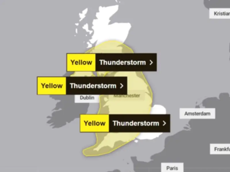
A new yellow weather warning for thunderstorms has been issued for Greater Manchester today, Sunday, August 30, with heavy rain, hail, frequent lightning and winds of up to 45mph forecast.
The Met Office has issued two separate yellow warnings for thunderstorms, both coming into effect at 11am today. Together, they cover almost the whole of the UK.
Warning details and affected regions
The first warning, which covers Greater Manchester and the rest of north west England, will remain in place all day until it is lifted at 11.59pm. The alert description reads: "Heavy showers and thunderstorms bringing disruption to transport, infrastructure and outdoor activities."

The Met Office warns of possible impacts including affected driving conditions, delays to train services, damage to some buildings and structures from lightning strikes, short-term loss of power, and some flooding.
This 12-hour warning affects large parts of the East Midlands, East of England, London and south east England, north east England, north west England, south west England, Scotland, Wales, West Midlands, and Yorkshire.
Forecast and additional hazards
The warning adds: "Showers, heavy and thundery, will reach southwest England and Wales later Sunday morning, before spreading and developing more widely during the afternoon.
"Whilst some areas will miss the heaviest showers, where they do occur 10-15 mm of rain is possible in less than an hour, with 30-40 mm possible over several hours, these larger totals most likely for parts of north and northwest England and southwest Scotland.
"Hail, frequent lightning and, in southern parts of England and Wales, wind gusts of 35-45 mph will be additional hazards. Heaviest showers and thunderstorms will become more isolated later in the evening."
A second alert, also coming into effect at 11am, is in force across parts of Scotland, Northern Ireland, and north east England, and will be lifted at 9pm.
Drought status unchanged
Despite the rainfall over the past week, the Environment Agency has revealed there have been no changes to the drought status of any areas across England.
Months of uncharacteristically dry and hot weather over the summer has left all of Wales and large parts of England in drought status, with any remaining areas in the stage before a drought, known as prolonged dry weather.
Greater Manchester, along with north east England, Yorkshire, Cumbria and Lancashire, Merseyside and Cheshire, remain in prolonged dry weather.
Water restrictions are still in place across large parts of England, including for customers of Bristol Water, which became the latest to impose a hosepipe ban. Bristol Water announced a temporary use ban across its area on August 26, with effect from August 27. Approximately 30 million people now have restrictions on their use of water.
The Environment Agency's latest update reads: "Despite recent rainfall and cooler weather, drought conditions continue across much of England. Rainfall remains well below average, with August rainfall to date only 34% of what would normally be expected for the time of year.
"Heavy rainfall moving across the country has resulted in over 40 flood alerts being issued on 27 August. Flooding can happen during a drought and will often be localised and of a short duration. There continues to be no change to Environment Agency Area drought status this week, with 71% of England by land classed as being in drought."