Met Office Issues Urgent Warning for 61 UK Regions as Storms Approach
The Met Office has issued an urgent alert to residents in 61 specific areas across the United Kingdom, advising them to prepare emergency kits immediately as a severe low-pressure system brings heavy rain and powerful winds. With up to 80mm of rainfall expected in some regions and wind gusts potentially reaching 70mph, the national weather service warns that flooding is a significant risk, particularly on already saturated ground.
Three Essential Items for Your Emergency Kit
In response to the impending恶劣天气, the Met Office is strongly recommending that individuals in affected areas assemble a basic emergency kit containing three crucial items:
- Torches – To maintain visibility during potential power outages or in low-light conditions caused by the storm.
- Batteries – Essential for powering torches and other critical devices, ensuring you are not left in the dark.
- Mobile phone power pack – To keep communication lines open, allowing you to stay informed and contact emergency services if necessary.
This preparation is vital as the unsettled conditions are forecast to persist throughout the week, with the Met Office emphasising that proactive measures can significantly enhance safety.

Detailed Breakdown of Weather Warnings and Affected Regions
The Met Office has activated three distinct yellow weather warnings for Tuesday, covering extensive parts of England, Wales, and Northern Ireland. Each warning highlights specific risks and geographical areas that residents need to monitor closely.
Rain Warning for Wales and England
An initial rain warning is in effect from 3pm today until midday tomorrow, targeting southern and southwestern England as well as southern and mid Wales. The Met Office predicts widespread rainfall of 20-30mm, with higher elevations such as Dartmoor, Exmoor, and the Brecon Beacons potentially receiving 50-80mm. This substantial precipitation, combined with already waterlogged soils, raises the likelihood of localised flooding. Strong south-easterly winds are also anticipated, exacerbating the hazardous conditions.
Regions under this warning include:
- London & South East England: Hampshire, Isle of Wight, Oxfordshire, Southampton, West Berkshire.
- South West England: Bath and North East Somerset, Bournemouth Christchurch and Poole, Bristol, Cornwall, Devon, Dorset, Gloucestershire, North Somerset, Plymouth, Somerset, South Gloucestershire, Swindon, Torbay, Wiltshire.
- Wales: Blaenau Gwent, Bridgend, Caerphilly, Cardiff, Carmarthenshire, Ceredigion, Merthyr Tydfil, Monmouthshire, Neath Port Talbot, Newport, Pembrokeshire, Powys, Rhondda Cynon Taf, Swansea, Torfaen, Vale of Glamorgan.
- West Midlands: Herefordshire, Shropshire.
Additional Rain Warning for South and South East England
A separate rain warning has been issued for the South and South East of England, valid from midnight until 12pm tomorrow. This alert forecasts 15-25mm of rain accumulating widely, with some areas possibly seeing 30-40mm and up to 50mm over certain hills. The persistent wet weather could lead to further flooding concerns in these regions.
Affected areas encompass:
- East of England: Thurrock.
- London & South East England: Bracknell Forest, Brighton and Hove, East Sussex, Greater London, Hampshire, Isle of Wight, Kent, Medway, Oxfordshire, Portsmouth, Reading, Slough, Surrey, West Berkshire, West Sussex, Windsor and Maidenhead, Wokingham.
Wind and Rain Warning for Northern Ireland
Northern Ireland is under a yellow warning for both wind and rain from 2am tomorrow until 9pm. Rainfall totals are expected to reach 15-25mm broadly, with 40-60mm possible on high ground, especially in eastern areas. The Met Office notes that the saturated ground conditions may result in flooding. Additionally, strong east to south-easterly winds are predicted, with peak gusts of 40-50mph inland and potentially 60-70mph along exposed coasts.
This warning applies to:

- Northern Ireland: County Antrim, County Armagh, County Down, County Fermanagh, County Londonderry, County Tyrone.
Meteorological Context and Broader Forecast
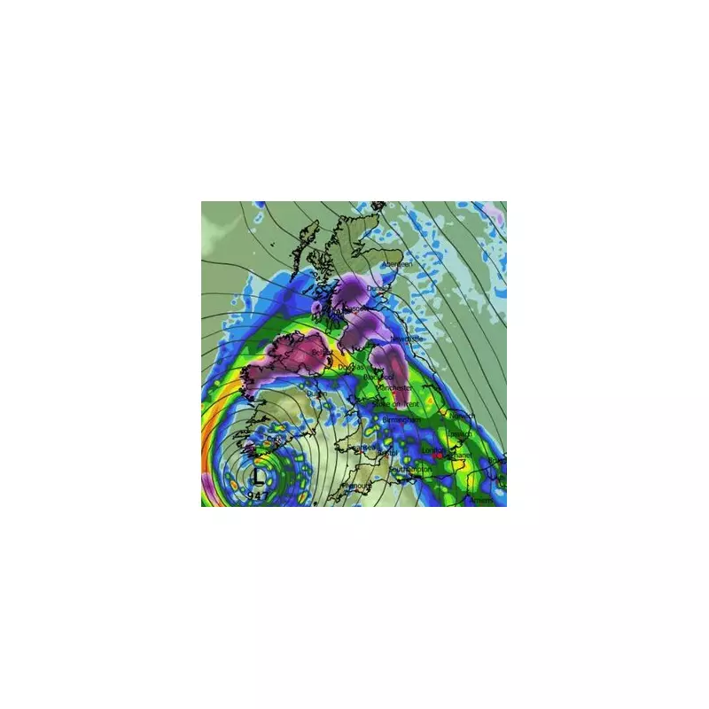
The Met Office explains that a succession of Atlantic weather systems is driving this period of wet and windy weather across the UK. A band of blustery rain is set to move in from the west today, initially impacting Northern Ireland and western Britain. As this rain encounters colder air in northern regions, snow is possible on higher ground, particularly across the Pennines and Scottish mountains.
Furthermore, a deep area of low pressure will introduce another spell of inclement conditions later today and into Tuesday. Gusty winds are likely in exposed locations, and the additional heavy rain could lead to flooding in areas that have already experienced persistent wet weather in recent days. In the north, colder air will linger, meaning hill snow remains a possibility on the northern edge of the weather system.
Residents in all 61 affected regions are urged to stay updated with the latest forecasts from the Met Office, avoid unnecessary travel during the worst of the weather, and ensure their emergency kits are readily accessible. By taking these precautions, individuals can better protect themselves and their properties from the potential impacts of this severe weather event.