
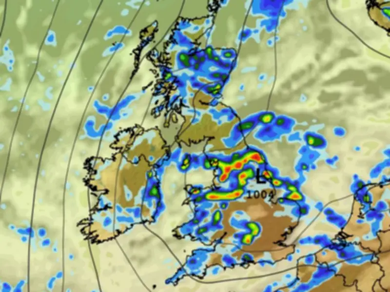
Heavy rain is expected to hit 17 counties in England and Wales on Thursday, according to weather maps and forecasts, offering some relief to regions officially in drought.
Met Office warns of widespread and heavy rain
The Met Office says “widespread and heavy” rain is on the cards from Thursday, with a risk of “thunder”. The showers are expected to move eastward and southward throughout the afternoon, based on the ECMWF weather model.
Most of England and all of Wales have already been declared in official drought status this summer, which is on track to be the warmest since records began. Millions of people are currently living under hosepipe ban restrictions.
Counties in the firing line
The data suggests heavy showers could impact 17 counties, primarily in northern and central areas, although some southern regions could also see rain. The affected counties are:
- Lancashire
- Yorkshire
- Cheshire
- Staffordshire
- Derbyshire
- Nottinghamshire
- Lincolnshire
- Shropshire
- Norfolk
- Suffolk
- Warwickshire
- Gloucestershire
- Oxfordshire
- Berkshire
- Caernarfonshire
- Denbighshire
- Flintshire
BBC forecast adds lightning and hail risk
The BBC forecast also suggests heavy rain this week, with “lightning and hail” potentially impacting some regions before the weekend. The BBC forecast states: “Wednesday, Thursday and Friday look to be unsettled days, as an area of low pressure sweeps across the UK, clearing into the North Sea later on Friday.
“There will be a mixture of sunny spells, areas of variable cloud, and scattered showers across the UK. The showers will be heavy in places with a chance of lightning and hail. Trending gradually cooler throughout too.”
The Met Office expects peak temperatures to drop towards the weekend, with highs of 23C on Thursday and 22C on Friday, compared to the 38C heat seen last week.




