
The United Kingdom is preparing for a significant cold snap as the Met Office has issued six yellow weather warnings for Wednesday, with heavy snow expected to impact at least 11 cities across the nation.
Widespread Warnings and Impending Arctic Blast
The national weather service has activated four separate snow and ice alerts, complemented by two additional ice warnings, signalling a dramatic shift to markedly colder conditions. This change is driven by a surge of Arctic air moving southwards, introducing a mix of wintry hazards, sharp frosts, and unsettled weather across the country.
According to Met Office Chief Forecaster Neil Armstrong, "Cold Arctic air from the north is firmly in charge of the UK’s weather, bringing the first notable cold snap of this autumn and giving an early taste of winter weather." He highlighted that the coldest conditions are anticipated on Wednesday and Thursday.

Timeline of the Snowfall
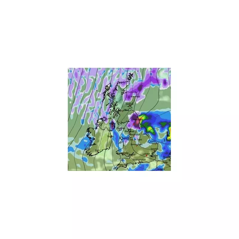
Weather models reveal a detailed timeline for the snowfall. The initial heavy flurries are forecast to hit the North East of England in the early hours of Wednesday, particularly affecting areas around Newcastle, Durham, and the Pennines. Eastern Scotland, including parts of the Highlands and Aberdeen, will also see significant accumulation, alongside Belfast in Northern Ireland and Snowdonia in Wales.
By 6am on Wednesday, the snow is expected to persist in eastern Scotland and the North East while spreading into the Midlands. Cities such as Birmingham, Leicester, Derby, Nottingham, and Sheffield are in the firing line for disruptive conditions.
The wintry weather is projected to move southwards by 9am, with a vast swathe of England from Birmingham down to London likely to experience snow showers. Meanwhile, eastern areas including Norwich and Ipswich are set for heavy rain.
Expected Snow Accumulations
By midday on Wednesday, the most substantial accumulations are predicted for the Scottish Highlands. The Cairngorms region between Inverness and Aberdeen could see a blanket of up to 20cm of snow.
In Northern England, a few centimetres are possible over the North Pennines and around Newcastle, Durham, and Carlisle. A light dusting is forecast for Belfast, while Snowdonia is also set for wintry weather. Even parts of southern England, including London, may see patchy light snow, though amounts there are expected to be minimal.
Armstrong further elaborated, "Whilst not all places will see lying snow, where showers are most frequent accumulations of 2-5 cm will be possible. On higher ground in Scotland, 15-20 cm could accumulate, and potentially as much as 15-25 cm over the North York Moors and Yorkshire Wolds."
This early taste of winter serves as a stark reminder for the public to prepare for hazardous travel conditions and to stay updated with the latest Met Office advisories.


