
UK Braces for Twin March Blizzards as Weather Maps Predict Snow in Eight Major Cities
Despite rising temperatures across the United Kingdom this week, shocking new weather maps reveal that two significant blizzards could sweep across England, Wales, Scotland, and Northern Ireland before the end of March. The forecasts indicate that as many as eight major cities may experience snowfall, disrupting the early spring period.
First Blizzard Expected on March 13
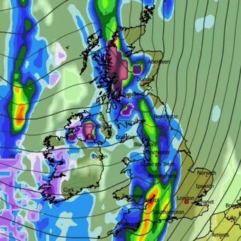
The GFS weather model shows the first system moving across the UK from the Atlantic on March 13. This initial blizzard is predicted to bring heavy snow to Northern Ireland and Scotland, while fierce rain batters Wales and England. By midday, maps indicate some snow will also fall in North Wales and northern parts of England, with torrential rain expected in London around this time.
Snow coverage maps for the morning of March 14 reveal snow settled on the ground around Gloucester, the far north-west of England, almost all of Northern Ireland including Belfast, and a massive portion of Scotland including Glasgow. This suggests significant accumulation from the first weather event.

Second Wider Storm Forecast for March 15
A broader storm is expected to follow on March 15, with maps showing snow falling over Scotland, northern England, and Wales at approximately 9am. By midday, the snowfall is projected to have reached the Midlands, expanding the affected areas considerably.
Snow coverage maps for 6pm on March 15 indicate that more cities could see snow settled on the ground, including Stoke-on-Trent, Manchester, Edinburgh, Dundee, and Aberdeen. This second blizzard appears poised to impact urban centers more directly than the first.
Contrasting Forecasts from Weather Authorities
Despite these dramatic predictions, BBC Weather expects temperatures to remain above average for this period. BBC forecasters acknowledge there could be one or two chilly interludes between frontal systems. Their forecast for March 9 to 15 states that Atlantic systems will become more active, bringing occasional rain and brisk winds, particularly targeting northern and western areas.
The Met Office's outlook for March 9 to 18 suggests the UK will remain at the interface between high pressure across Europe and low pressure over the North Atlantic. Western areas will likely see spells of rain and stronger winds, while eastern parts should experience drier interludes, though some rain remains possible. Towards the middle of March, unsettled conditions may become more widespread, with all parts seeing increased chances of rain and stronger winds.
Both authorities agree that temperatures should overall pan out slightly above average for most areas throughout this period, creating a complex weather pattern where brief cold snaps could produce significant snowfall despite generally mild conditions.


