
UK Braces for Arctic Blast with Snow and Ice Warnings Issued Nationwide
Forecasters have issued urgent warnings as a surge of Arctic maritime air descends upon the United Kingdom, bringing with it the threat of significant snow and ice accumulation. The Met Office has activated yellow weather alerts for large swathes of the country, cautioning that travel disruption is likely due to hazardous conditions on roads and pathways.
Timeline and Coverage of Weather Warnings
The Met Office yellow warnings for snow and ice will be in force across most of Scotland from 4pm on Thursday until midday on Friday. Simultaneously, northern England will be under alert from 7pm on Thursday through to midday the following day. These advisories come on the heels of existing yellow rain warnings in western and eastern Scotland, which remain active until midnight on Wednesday due to risks of flooding.
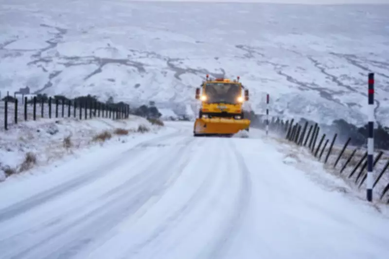
In Scotland, snow showers are anticipated to begin affecting high ground on Thursday evening, gradually descending to lower levels overnight. By Friday morning, accumulations of 1-2cm are possible on low ground, with 2-5cm expected on hills above 300 metres. In some very localised areas, up to 10cm of snow could settle. The warning encompasses all of Scotland except for the westerly parts of the Hebrides and Argyll and Bute.

Impact on England and Health Alerts
South of the border, the initial snowfall in England is predicted to concentrate over higher hills before spreading to lower elevations through Thursday evening. Settling snow will primarily be confined to high ground, with 2-5cm possible above 200 metres and up to 10cm in locations above 300 metres. The warning covers North East and North West England, parts of the Midlands, and Yorkshire and Humber.
Concurrently, the UK Health Security Agency has issued a yellow cold health alert for several regions, including the East Midlands, West Midlands, North East, North West, and Yorkshire and The Humber. This alert underscores the health risks associated with the plummeting temperatures.
Forecaster Insights and Additional Risks
Met Office spokesman Grahame Madge provided context, stating, "We are seeing an incursion of Arctic maritime air that will bring temperatures down, extending southwards from Scotland into northern England. While we are not expecting particularly impactful snow, conditions will feel quite different with colder air arriving." He noted that the snow and ice conditions are expected to be brief, with another system from the Atlantic anticipated over the weekend.
On Wednesday, heavy rain persisted across eastern Scotland, with forecasts predicting an additional 15-25mm widely and 30-40mm over high ground. This rainfall, following recent precipitation, raises concerns about disruption and potential flooding. Snow is also likely above 300-400 metres in areas like Aberdeenshire, Angus, and Perthshire, where 5-10cm may accumulate by Wednesday's end.
The Scottish Environment Protection Agency has escalated the situation by issuing three flood warnings and seven flood alerts, highlighting the compounded risks of waterlogging and icy surfaces. As the rain and snow clear south during Friday's early hours, temperatures are expected to drop rapidly, leading to ice formation on untreated surfaces and exacerbating travel hazards.


