
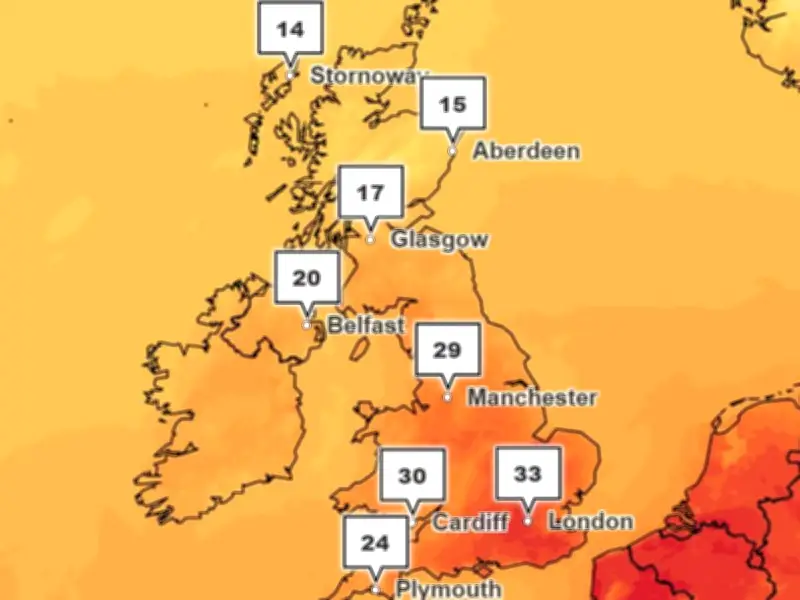
The Met Office has forecast temperatures reaching 29C in Greater Manchester in the coming week, with the region set to meet its heatwave criteria for a fourth time this summer. The hottest day is expected on Monday, August 3.
Fourth heatwave for Greater Manchester
Forecast highs of 25C on Sunday and 25C on Tuesday, along with the 29C peak on Monday, mean the region will see three or more consecutive days at 25C or higher – the Met Office's heatwave criteria.
The UK has already endured its fourth heatwave of the summer so far, with temperatures topping 35C over the last week. Health authorities have warned that England is on track this year for the highest number of deaths caused by such hot spells since current figures began.
United Utilities: no water restrictions planned
Large parts of the UK have entered drought conditions following weeks of dry and hot weather, with water restrictions in force for millions of people. United Utilities, which supplies water to Greater Manchester and north west England, has urged customers to "use water wisely" but said it has no plans to enforce restrictions.
"There are no plans for any restrictions in the North West," a United Utilities spokesperson said. "And our reservoir levels are where we would expect them to be for this time of year, thanks to a wetter-than-average start to 2026."
"However, the recent hot weather has driven record demand. At the peak of the heatwave, we supplied more than 2 billion litres of water a day across the North West – around 200 million litres more than usual, the equivalent of adding a city the size of Liverpool to our daily demand. That demand comes not only from households, but also from businesses, farmers and the emergency services responding to moorland fires."
United Utilities added: "While we're in a strong position, we always encourage customers to use water wisely, as a few small changes can make a big difference in helping to ensure there's enough water for everyone throughout the summer."
Very warm and humid conditions
The Met Office forecast for north west England between Monday and Wednesday described the weather becoming "very warm and humid". "Turning very warm and humid from Monday with an increasing chance of showers," the forecast reads. "These potentially heavy and thundery at times. Feeling very warm in the sunny spells and light winds."
Other parts of the UK, particularly in the south of England, could surpass 30C, with temperatures of 33C forecast in London and the surrounding areas. Despite the hot conditions, the Met Office said the hot and humid spell "won't last long" and "may be accompanied by some scattered thundery downpours".
Changeable period likely from August 6
Looking ahead to the long-range forecast covering August 6 to 15, the Met Office has warned of a "changeable" period. "A generally changeable period looks likely and many places are likely to see some rain or showers at times, interspersed with drier and sunnier spells," the forecast states.
"Many areas will start with a few drier days, although there will be some showers in the north. There is, however, a chance that deeper low pressure brings more widespread unsettled conditions for a time. Into mid August more changeable or unsettled conditions probably become prevalent. This may be due to Atlantic frontal systems or thundery plumes moving north from the continent or a combination of both."
"Temperatures will likely be a little above average, and there is the potential for some very warm or hot and humid spells, especially in the south, although perhaps not the heat we have seen in recent weeks."




