
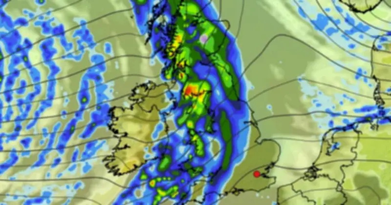
Weather maps show a 551-mile sheet of rain set to sweep across the UK on Friday, October 9, stretching from the northern tip of mainland Scotland down to Devon, with some areas seeing rain rates between 1.5mm and 4mm per hour.
Rain to cover most of the UK
According to forecaster WXCharts, the rain will move in from the Atlantic in the early hours, covering Ireland before arriving in the UK, then dissipating into smaller patches over the weekend. The worst-affected areas will be in Scotland, but rain will also spread to large parts of England, Wales and Northern Ireland.
Maps show spots of purple in Scotland, signalling the possibility of snow. The rain follows a week of mixed conditions, with occasional heavy rain across the UK.
Areas affected on October 9
WXCharts lists the areas of England covered by rain on Friday, October 9, including Northumberland, Tyne & Wear, Cumbria, County Durham, North Yorkshire, East Riding of Yorkshire, West Yorkshire, South Yorkshire, Lancashire, Greater Manchester, Merseyside, Cheshire, Derbyshire, Shropshire, Staffordshire, Nottinghamshire, Lincolnshire, Rutland, Leicestershire, West Midlands, Warwickshire, Worcestershire, Herefordshire, Oxfordshire, Northamptonshire, Gloucestershire, Bristol, Somerset, Wiltshire, Devon, Dorset and Cornwall.
In Scotland, affected areas include Angus, Argyll, Ayrshire, Banffshire, Berwickshire, Buteshire, Caithness, Clackmannanshire, Cromartyshire, Dumfriesshire, Dunbartonshire, East Lothian, Fifeshire, Inverness-shire, Kincardineshire, Kinross-shire, Kirkcudbrightshire, Lanarkshire, Midlothian, Moray, Nairnshire, Orkney, Peeblesshire, Perthshire, Renfrewshire, Ross-shire, Roxburghshire, Selkirkshire, Shetland, Stirlingshire, Sutherland, West Lothian and Wigtownshire.
In Wales, the rain covers the Isle of Anglesey, Gwynedd, Conwy, Denbighshire, Flintshire, Wrexham, Ceredigion, Powys, Pembrokeshire, Carmarthenshire, Swansea, Neath Port Talbot, Bridgend, Vale of Glamorgan, Rhondda Cynon Taff, Cardiff, Merthyr Tydfil, Caerphilly, Newport, Torfaen, Blaenau Gwent and Monmouthshire. Northern Ireland will see rain in the early hours, covering County Antrim, County Armagh, County Fermanagh, County Down, County Derry and County Tyrone.
Met Office outlook for October
For the week beginning Monday, October 5, the Met Office has said the south of the UK will "likely be under the influence of high pressure for the first few days", bringing plenty of dry weather, despite some chilly nights and foggy mornings. In the north, a "rather more changeable pattern will continue, with occasional rain and windy conditions at times".
"Broadly changeable weather patterns look to continue through mid-month, with ridges of high pressure extending from the southwest, interspersed by Atlantic frontal systems," the forecast reads. "These could be associated with quite deep and fast-moving depressions, bringing the potential for windy weather more widely, again most likely in the north. Temperatures probably near or slightly above normal overall, with day to day variations."
WXCharts' maps currently show heavy rain arriving again in the UK on Tuesday, October 13, with the worst-affected areas spread across England, Wales and Scotland. The Met Office predicts that the "second half of October will probably maintain a changeable pattern overall with showers or longer spells of rain often moving in from the Atlantic".
The forecast adds: "This means the wettest and at times windiest weather is more likely in the west and northwest, and relatively drier conditions more likely towards the south and east. With a westerly type considered most likely, this would support temperatures remaining close to or a little above average overall. However, there is a chance that more slowly evolving weather patterns develop, which could either lead to longer drier spells more widely or rainfall accumulating in climatologically drier areas."




