
Striking weather maps have unveiled a severe Arctic freeze set to engulf the United Kingdom, with at least 18 regions bracing for blizzards and plummeting temperatures as low as -4C. The wintry onslaught is predicted to commence from midnight on Wednesday, March 25, initially targeting Scotland before spreading into eastern England by the evening.
Widespread Snowfall Across Multiple Regions
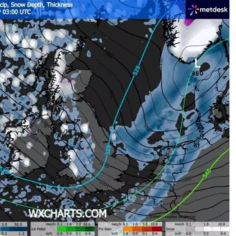
According to data from WXCharts utilizing Metdesk information, significant snowfall is anticipated in diverse areas including Essex and Suffolk in the south, Powys in the west, and the Scottish Highlands in the north. The maps depict extensive white and grey patches indicating heavy snow accumulation, with conditions expected to intensify early on Wednesday.
Timeline and Impact of the Arctic Blast
The freezing conditions are forecasted to initiate around midnight on Wednesday and persist throughout the day, with Scotland bearing the brunt initially. By 3am, council areas such as Aberdeenshire, Argyll and Bute, and Perth and Kinross are likely to experience substantial snowfall. Temperatures are projected to dive to a chilling -4C, marking a stark contrast to recent milder weather.

Northern England, including Northumberland and North Yorkshire, will also encounter snow in the early hours before it dissipates by evening and shifts eastward. By 6pm, lighter snow is expected to blanket parts of Suffolk, Cambridgeshire, Essex, and Norfolk, while snow depths in Scotland could reach up to four inches.
Meteorological Warnings and Expert Insights
Rainfall and sleet are anticipated throughout the day, adding to the hazardous conditions. The Met Office has issued warnings of a sudden shift in weather patterns this week. Steven Keates, Met Office deputy chief forecaster, emphasized, "After a spell of mild and brighter weather, the UK will become increasingly unsettled in the coming days. A series of weather fronts will bring bouts of rain, strong winds and much colder air by midweek. Wednesday could be quite a shock to the system."
This dramatic change follows a period of unseasonably warm weather, with temperatures reaching 16C in Cardiff and 15C in Ross-on-Wye, Herefordshire, just days prior. Jo Farrow, a meteorologist with Netweather, noted on its blog, "For the new working week, the trend is to colder conditions with mention of snow showers from the northwest. It will become windy as the settled weather under the current high pressure is shoved aside by an Atlantic low pressure."
Full List of Affected Areas
The following regions are expected to see snow on Wednesday:
- Aberdeenshire
- Angus
- Argyll and Bute
- Cumbria
- Cambridgeshire
- Glasgow
- Gwynedd
- Essex
- Highland
- Moray
- Northumberland
- Norfolk
- North Yorkshire
- Orkney Islands
- Perth and Kinross
- Powys
- Scottish Borders
- Shetland Islands
- Suffolk
Residents are advised to prepare for potential travel disruptions and hazardous conditions as the Arctic freeze takes hold across the nation.


