
Storm Chandra Brings Widespread Travel Disruption and Flooding Across UK
Storm Chandra has unleashed significant travel disruption and widespread flooding across much of the United Kingdom, as powerful winds and torrential rain continue to batter numerous regions. The severe weather system has prompted multiple weather warnings and forced the closure of major transport routes, with authorities urging the public to exercise extreme caution.
Major Bridge Closures and Transport Chaos
The M48 Severn Bridge was completely closed this morning due to dangerous wind conditions, while The Humber Bridge has been shut to all high-sided vehicles. National Rail has issued a specific warning that poor weather conditions may severely affect South Western Railway services until the end of the day. Traffic between England and Wales is being diverted over the M4 Prince of Wales Bridge as alternative routes become necessary.
Gwent Police reported that the A40 has been flooded between Abergavenny and Raglan, rendering the road impassable. Several roads across Dorset, Somerset and east Devon have also been closed due to extensive flooding, creating significant challenges for local communities and emergency services. In Northern Ireland, a number of schools have been forced to close as a precautionary measure against the worsening conditions.

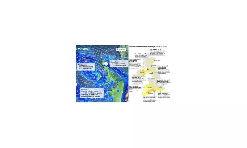
Multiple Weather Warnings in Force
Forecasters had previously warned that flooding and travel disruption were highly likely, with significant snow expected across higher ground in northern parts of England and Scotland. Several weather warnings remain in force on Tuesday, including amber warnings for both south-west England and the eastern coast of Northern Ireland for rain and wind respectively.
The Met Office has indicated that gusts of 60 to 70mph will affect eastern Northern Ireland, with possible 75mph gusts in coastal locations. Meteorological experts have emphasised that easterly winds of this strength are particularly unusual and are likely to prove highly impactful across affected regions.
Regional Impact and Specific Warnings
An amber warning for wind remains in place on the eastern coast of Northern Ireland from 5am to 9pm on Tuesday, with an additional yellow rain and wind warning covering the whole of Northern Ireland throughout the day. Across the south west of England, where Storm Ingrid recently wreaked havoc and washed away part of a historic pier, forecasters anticipate further downpours from Storm Chandra.
An amber warning for rain is currently active for south Devon, much of Dorset, southern Somerset and south-east Cornwall until 9am on Tuesday. Meteorological predictions suggest 30-50mm of rain could fall widely across these areas, with up to 60-80mm possible over higher ground of south Dartmoor.
Extensive Yellow Warnings Across Multiple Regions
Less severe yellow warnings cover a more extensive area of southern England, as well as parts of northern England and Scotland. A yellow warning for wind specifically affects Cornwall, south-west Wales and parts of northern Devon from 5am to 4pm on Tuesday, with an additional yellow wind warning in force for southwestern Scotland from 5am to midnight.
Yellow warnings for both rain and snow have been issued for the Pennines and south-west Scotland from midnight to 5pm on Tuesday, where 2-5cm of snow could fall widely and as much as 10-20cm could accumulate at higher elevations. A further yellow warning for rain and snow covers much of central Scotland from 6am to midnight on Tuesday.
Additional yellow warnings for rain remain in place from midnight until midday on Tuesday for much of south-east England, and for south-west England and south and central Wales from 1pm on Monday to 10am on Tuesday.
Flood Warnings and Emergency Response
Early on Tuesday morning, there were 69 flood warnings active across England, with the majority concentrated in south-west England and four specific warnings in Yorkshire. Scotland has issued flood warnings for Aberbothrie and the River Isla at Coupar Angus, while 17 flood alerts remain active across various regions of Wales.

Met Office chief forecaster Paul Gundersen provided detailed analysis: 'Initially, strong winds will impact the Isles of Scilly, western Cornwall and south-west Wales which are still vulnerable after Storm Goretti, with gusts of 70 to 80mph possible here. Heavy rain is an additional hazard as it falls on saturated ground in Dorset and southern parts of Devon, Somerset and Cornwall. As Chandra interacts with colder air further north, snow becomes a significant hazard, with 10-20cm of snow possibly accumulating over higher ground in the Pennines, southern Scotland and the Highlands.'
Gundersen emphasised the complexity of the weather situation, stating: 'With a complex spell of weather, it's important people stay up to date with the forecast and any warnings in your area.'
Safety Advice from Emergency Services
RAC mobile servicing and repairs team leader Nick Mullender issued urgent safety guidance for motorists: 'Flooding is highly likely, making many roads dangerous. Our message to drivers is simple: do not drive through standing water unless you are completely certain the water is shallow enough and it's safe to do so. In these conditions, drivers need to slow down and stay alert. Wet roads can double stopping distances, so taking a cautious, steady approach and allowing extra time to react is essential.'
Mullender added important maintenance advice: 'And if your vehicle already has known faults, now is not the time to take risks. Avoid unnecessary journeys and get issues fixed promptly by a trusted mobile mechanic or local garage.'
Storm Chandra represents the next officially named storm from the western Europe storm naming group list, which is shared between the United Kingdom, Ireland and the Netherlands. The naming convention helps improve communication about severe weather events across national boundaries.


