
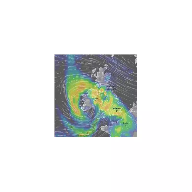
Storm Chandra Sweeps Across UK with Heavy Snow and Severe Weather Warnings
The Met Office has issued urgent warnings as Storm Chandra, a deep area of low pressure, batters the United Kingdom today. This powerful weather system is bringing a dangerous mix of strong winds, heavy rain, and significant snowfall to many regions, with the Southwest of England particularly affected due to already saturated ground.
Exact Timing and Snowfall Predictions
Weather maps indicate that snow began falling as early as 6am this morning across several areas, including Aberdeenshire, the Scottish Highlands, Ayrshire, North Yorkshire, and Derbyshire. The snowfall is expected to intensify throughout the morning, with the Peak District regions of Derbyshire and Staffordshire facing the heaviest accumulations by around 9am. Meteorologists forecast that up to eight inches (20cm) of snow could accumulate on higher ground, especially in parts of Scotland, northern England, and the Midlands.
Met Office Chief Forecaster Issues Stark Warning
Paul Gundersen, Chief Forecaster at the Met Office, emphasised the severity of the situation. He stated, "As Chandra interacts with colder air further north, snow becomes a hazard, with 10-20cm of snow possibly accumulating over higher ground in the Pennines, southern Scotland, and the Highlands. With a complex spell of weather, it's important people stay up to date with the forecast and any warnings in your area."

Multiple Weather Warnings in Effect
Currently, there are three separate weather warnings for snow, extending as far south as Derbyshire and Staffordshire. Additionally, amber alerts have been issued for rain and wind in regions such as Devon, Dorset, and Somerset. The Met Office has highlighted that these conditions pose a "danger to life" in some parts, particularly the Southwest of England, and are likely to cause significant delays on roads and railways.
Regional Impacts and Travel Disruptions
In North Yorkshire, the heavy snow is expected to lead to delays on roads and railways, along with potential interruptions to power supplies. By midday, snowfall will become less widespread but will remain particularly heavy in areas like County Durham, North Yorkshire, and Dumfries and Galloway. As the band of low pressure moves northeastwards in the afternoon, it will turn to rain across the east coast, including Humberside, with the heaviest downpours anticipated in Northumberland during the evening rush hour.
Wind and Rain Hazards Exacerbate Risks
Mr. Gundersen further explained, "Chandra will bring a range of hazards to the UK through Monday night and Tuesday. Initially, strong winds will impact the Isles of Scilly, western Cornwall, and southwest Wales, which are still vulnerable after Storm Goretti, with gusts of 70 to 80mph possible here. Heavy rain is an additional hazard as it falls on saturated ground in Dorset and southern parts of Devon, Somerset, and Cornwall."
Residents across the UK are urged to monitor local forecasts closely and heed all weather warnings to ensure their safety during this severe weather event.


