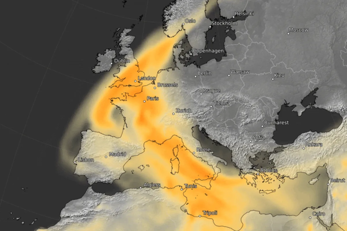
Intense Saharan Dust Storm Set to Engulf Southern Europe This Week
Saharan Dust Storm to Sweep Europe, Affecting Air Quality

Intense Saharan Dust Storm Set to Engulf Southern Europe This Week

An intense Saharan dust plume is forecast to sweep into Europe this week, transporting sand from North Africa across the Iberian Peninsula and western Mediterranean region. According to the EU's Copernicus Atmosphere Monitoring Service (CAMS), this atmospheric event will bring hazy skies, colourful sunrises and sunsets, and potential dust deposits if rainfall occurs.

Geographic Impact and Timeline

The dust storm will particularly affect Spain, Portugal, and parts of France around Friday before the plume progresses northward toward the North Sea and Scandinavia. While Britain may experience some effects, these are expected to be far more marginal compared to southern European nations.

Mark Parrington, a senior scientist at Copernicus, explained that while dust transport is fairly common during this season, the current episode is particularly remarkable in its intensity and direct path. "It is going to be visible more at times of sunrise or sunset, deeper orangey colors," Parrington told The Independent.

Mechanisms and Potential Consequences

The plume is being driven by a low-pressure system named Storm Regina by Portugal's weather service, which is transporting dust directly from North Africa into Europe. This differs from a previous event between 20-25 February that was linked to "Calima" winds blowing dust toward the North Atlantic.

Potential impacts include:

  • Air quality degradation across affected regions
  • Reduced visibility that could disrupt air travel
  • Dust deposits on surfaces if rainfall occurs (wet deposition)
  • Health concerns for vulnerable populations

"Noticeable surface air quality impacts are forecast across parts of Spain, Portugal and France," Parrington stated. "At higher altitudes, the plume is expected to reach the North Sea and Scandinavia."

Historical Context and Comparisons

This event follows similar historical occurrences:

  1. In March 2024, a Saharan dust cloud blanketed southern Europe, causing air pollution up to 10 times recommended levels in holiday hotspots
  2. Crete authorities ordered children and elderly residents to stay indoors during that event
  3. In 2022, orange skies were observed over London when similar dust reached British shores

Parrington emphasized that the current plume will be more intense across the Iberian Peninsula compared to the February event and more directly driven by Borrasca-type winds transporting dust straight into the western Mediterranean region.

Practical Implications for Residents and Travelers

The severity of impacts will largely depend on whether rainfall accompanies the dust. "The way that it could reach the ground level is if it mixes with any rain," Parrington explained. "Then the dust can get absorbed by the rain and when it falls to the ground it might leave a dusty residue on cars or windows."

He added that such events have previously affected civil aviation through reduced visibility, making operations more difficult. The Copernicus monitoring system is particularly suited for tracking these transboundary transport situations that can affect multiple European nations simultaneously.

Residents in affected areas should prepare for potential air quality advisories and reduced visibility, particularly around sunrise and sunset when the dust's effects will be most visually apparent through enhanced orange and red hues in the sky.