
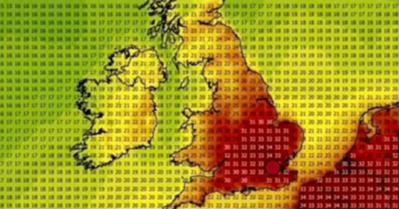
The Met Office has issued its forecast for the next UK heatwave, as weather maps from WXCharts indicate potential highs of up to 34C in the coming days. The UK has experienced an unprecedented level of hot weather and dryness over the past few weeks and months, with temperature records broken in May and June, and Brits regularly facing days of 30C or more.
Historic July and August outlook
The Met Office has described July as a 'historic' month in terms of dryness, sunshine, and exceptional warmth. Its forecast for the beginning and middle of August reveals that temperatures above average are likely in some areas, with the possibility of conditions becoming very warm or hot.
WXCharts, a separate UK-based forecasting service, currently shows temperatures as high as 34C next week, with Brits bracing for even more hot weather in what has proven to be an uncomfortable summer for many.
WXCharts maps show 34C on August 12
WXCharts' current maps show temperatures well above average on August 12, with highs of 34C in areas of the south. Its weather maps turn red in the south and east of England, as well as areas of Wales. Temperatures of above 30C stretch from Sussex up to Lincolnshire, with temperatures in the high 20s stretching to areas like Yorkshire and Devon.
Met Office forecast for August 10-19
Meanwhile, the Met Office says that mixed weather conditions are expected for the period between Monday, August 10 and Wednesday, August 19. It predicts a "relatively settled start to the period, with mainly dry conditions on Monday, although with scattered showers across northern areas".
"Then through the following week, more changeable conditions are likely across northwestern parts, with some spells of rain and stronger winds interspersed by drier periods," the forecast adds. "Whilst southeastern areas will generally see more settled and drier conditions. Further into August, lower pressure may start to track further south or east."
"This means there is a greater chance of frontal systems or thundery interludes to affect southern and eastern areas in comparison to recent weeks, though rainfall amounts could be quite variable, with some areas still seeing relatively little. For the most part, temperatures look to remain above average, especially in the south, and perhaps turning very warm or hot."




