
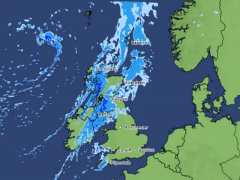
A large band of rain is forecast to sweep across the UK this weekend, according to Met Office weather maps. The band will move in a southward direction, bringing wet weather to many areas.
Driest July on record
This comes as England and Wales have provisionally recorded their driest July on record, with Southern England seeing its driest month ever recorded in a series dating back to 1836. Several parts of England are currently facing water restrictions such as hosepipe bans due to the lack of rain over the summer so far.
United Utilities, which supplies water to north west England, says there are no plans to impose restrictions, but people should "use water wisely".
Thunderstorm warning
The Met Office has issued an 11-hour thunderstorm warning affecting parts of the UK on Wednesday (August 5), where "slow-moving heavy showers and thunderstorms may cause some disruption" across six areas in Scotland. The UK weather agency warns that there is a small chance that homes and businesses could be flooded quickly, with damage to some buildings from floodwater, lightning strikes, hail or strong winds.
Weekend rain band
By the weekend, another band of rain is set to sweep across the UK, moving in from the west, hitting Ireland at around 7am on Saturday (August 8), reaching Scotland by midday and sweeping over Cumbria and Greater Manchester into the afternoon.
The UK-wide weather forecast for the weekend reads: "A band of rain affecting the northwest on Saturday will sink southwards on Sunday, though some areas will remain dry. Average temperatures at first."
The Met Office weekend forecast for the north west reads: "Largely dry with sunny spells on Friday and Saturday. In the sunshine it will be feeling increasingly warmer, before a risk of rain returns on Sunday."
Long-range outlook
Within the long-range forecast for the UK, covering the period between August 9 and 18, the Met Office says there will be a mixture of high and low pressure, with "further wet weather" in the north west. The forecast reads: "Rain or showers clearing on Sunday, with high pressure bringing more settled weather for most on Monday. High pressure will remain prevalent across the UK for a time, but low pressure in the Atlantic may bring further wet weather to northwestern parts."
Further into August, high pressure may become more dominant towards the north or northwest of the UK, with lower pressure to the south or east. This means there is a greater chance of frontal systems or thundery interludes to affect southern and eastern areas in comparison to recent weeks, though rainfall amounts could be quite variable with some areas still seeing relatively little. For the most part, temperatures look to remain above average, especially in the south, and perhaps turning very warm or hot.
Looking even further ahead at the period between August 19 and September 2, the Met Office expects low rainfall and above average weather. "The broad theme of high pressure remaining in place at least close to the UK seems most probable, with occasional more unsettled or changeable interludes, either resulting from Atlantic frontal systems or thundery plumes," the long range forecast reads. "This means that rainfall amounts overall are more likely to be below normal than above. Temperatures will probably be above average and some spells of hot weather and heatwaves are possible, especially in the south."




