
Easter Travel Chaos Looms as Gale Force Winds Set to Batter Northern UK
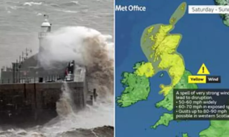
Britons preparing for an Easter getaway are facing significant travel disruption as gale force winds are forecast to batter the northern half of the country. The Met Office has issued a yellow weather warning for very strong winds affecting Scotland, Northern Ireland, and parts of north Wales and northern England.
Timing and Intensity of the Storm
The storm is expected to commence from 6pm on Saturday, persisting until 12pm on Sunday. Gusts of 50-60mph are anticipated across northern regions, with potential peaks reaching as high as 90mph in western areas of Scotland. These conditions could escalate into a nightmare for holidaymakers, with warnings of traffic jams and delays to rail, air, and ferry transport.
Potential Hazards and Disruptions
Forecasters have cautioned that the strong winds could cause damage to buildings and power lines, leading to power cuts that may leave some households in darkness. There is also a risk of injuries as large waves might throw rocks and stones from beaches onto roads, pavements, and homes, while building tiles could be blown from roofs.

Exposed routes and bridges are likely to become perilous, potentially causing delays for high-sided vehicles or even resulting in closures. The Bank Holiday Weekend will begin with an unsettled start on Good Friday, featuring outbreaks of rain that could become heavy in some places, interspersed with brighter interludes. Conditions may turn blustery at times, especially in areas surrounding the Pennines.
Expert Meteorological Insights
Met Office deputy chief meteorologist Dan Holley explained, 'A significant cold plunge from Canada into the North Atlantic will impact our weekend weather, strengthening the jet stream and spinning up a deep area of low pressure towards the north-west of the UK on Saturday night. This will lead to a spell of very strong winds later on Saturday and overnight into the morning of Easter Sunday.'
He added that winds should gradually ease through Easter Sunday as the low-pressure system moves into the North Sea. Tom Morgan, Met Office operational meteorologist, noted that while much of the UK will experience unsettled weather by the end of the week, it does not necessarily indicate a washout over the Easter Bank Holiday weekend.
'There's actually going to be quite a lot of dry weather, particularly across England and Wales, but it will be turning windier for all,' he said. 'We could see some particularly damaging winds in parts of Scotland, so it is here where we are most likely to need to escalate the warnings. We could also see some disruption to ferry services, transport, bridge closures, and potentially some power lines coming down.'
Weekend Weather Outlook
Overnight on Friday, a ridge of high pressure will bring cooler air, resulting in a frosty start to Saturday. For most areas, Easter Monday is expected to be fine, dry, and bright. However, the immediate focus remains on the severe wind conditions anticipated for the northern regions.
Context of Recent Weather Patterns
Separate figures published by the Met Office on Wednesday reveal that March was provisionally one of the warmest on record in England and Wales. Long periods of above-average temperatures and prolonged sunshine contributed to Wales experiencing its joint fourth warmest March and England its joint sixth warmest since comparable data began in 1884.
Across the entire UK, it was the joint tenth warmest March on record. There was a pronounced north-south split in terms of rainfall last month, with southern England seeing 37% less than the long-term average, while northern England and Scotland experienced 14% and 19% above average rainfall respectively.


