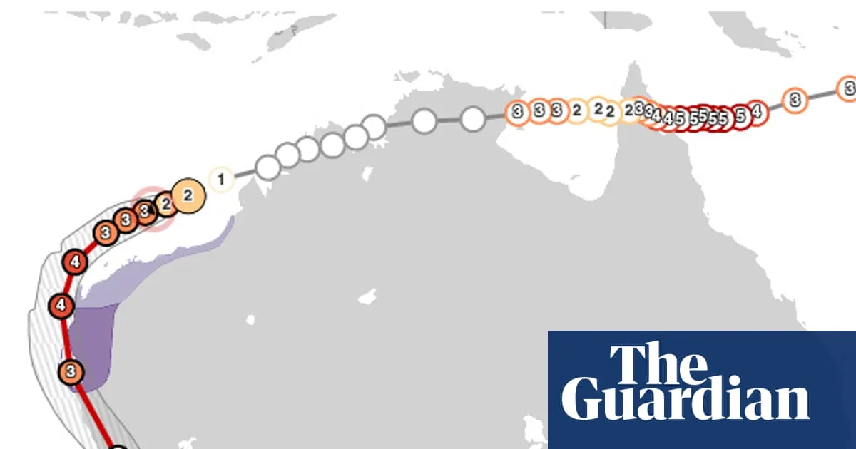
Cyclone Narelle's Rare Triple Landfall Path Across Australia Explained
Cyclone Narelle's Rare Triple Landfall Path in Australia

Tropical Cyclone Narelle's Historic Triple Landfall Across Australia

A tracking map illustrates the path of Tropical Cyclone Narelle as it traversed Australia and moved over Western Australia. This storm has carved a very unusual trajectory, becoming only the third recorded system to make landfall in three Australian jurisdictions, and the first in more than 20 years.

The Unprecedented Journey of Cyclone Narelle

When Tropical Cyclone Narelle crossed the Western Australian coast on Friday afternoon, it marked a significant meteorological event. Over the preceding week, the severe storm battered communities across far north Queensland and the Northern Territory. Initially striking far north Queensland as a high-end category 4 cyclone, it then reached the Northern Territory as a category 3 storm last Saturday before continuing westward to the Indian Ocean. By the time it approached Perth on Saturday, likely passing east of the capital, it had travelled more than 5,500 kilometres (3,400 miles).

How Common Are Multiple Landfall Cyclones?

The last storms to achieve landfall in three Australian states and territories were Cyclone Ingrid in 2005 and Cyclone Steve in 2000. Such occurrences are historically rare, but when they do happen, they often follow a looping trajectory similar to Narelle's path. Dr Milton Speer, a fellow at the University of Technology Sydney and former Bureau of Meteorology forecaster, explains that these cyclones get captured by mid-latitude westerly winds instead of following the typical tropical easterly trade winds. The exact path depends on upper-level wind circulation patterns in the Earth's troposphere, where weather occurs, with Narelle being pushed east by an upper-level low pressure trough.

Wide Pickt banner — collaborative shopping lists app for Telegram, phone mockup with grocery list

Dr Joseph Christensen, a University of Western Australia historian specialising in cyclones and extreme weather, notes that Narelle's path is very unusual, with only one or two known precursors. Reliable meteorological data on cyclones in Australia only began in the 1970s, making it difficult to gauge historical frequency. Typically, West Australian cyclones form in the Timor Sea off the Kimberley coast and move south-easterly, but Narelle took the opposite east-to-west route.

The Role of Global Heating in Narelle's Trajectory

Climate scientists have indicated that Cyclone Narelle's early formation and intensification were likely fuelled by global heating, pointing to record ocean temperatures in the Coral Sea in the weeks before the storm. Cyclones require ocean temperatures above 26.5°C to form, along with favourable atmospheric conditions. The Coral Sea, where Narelle developed, has experienced record highs recently, including the hottest December, February, summer, calendar year, and financial year, according to climate scientist Andrew Watkins.

Dr Speer adds that global heating is making cyclones more likely to travel long distances from east to west due to fewer westerly winds near the equator. Additionally, a warmer atmosphere can hold more moisture, potentially increasing rainfall from such storms. This analysis highlights the growing impact of climate change on extreme weather patterns in Australia.

Pickt after-article banner — collaborative shopping lists app with family illustration