Tropical Cyclone Narelle Makes Landfall in Western Australia with Severe Flooding Threat to Perth
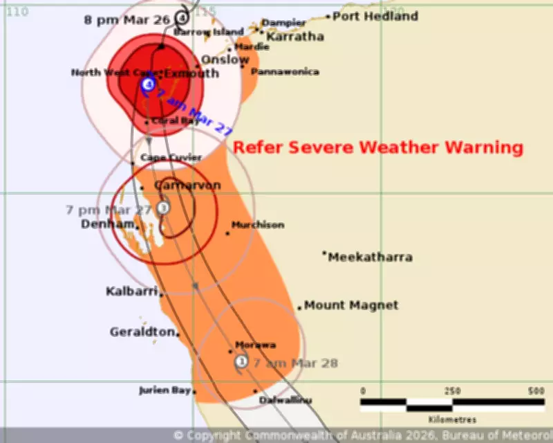
A tracker map from the Bureau of Meteorology shows Tropical Cyclone Narelle positioned off the remote north-west coast of Western Australia at 1am AEDT, with the massive storm expected to bring significant flooding to Perth as it progresses. The destructive category four system is forecast to weaken slightly upon crossing the WA coast late on Friday, targeting an area between Carnarvon and Kalbarri, but it will still unleash wind gusts reaching up to 250km/h.
Path and Intensity of Cyclone Narelle
In an update issued just before 7am AWST (10am AEDT) on Friday, the Bureau of Meteorology reported that Cyclone Narelle was located 40km west south-west of Exmouth and had begun to weaken, though it is anticipated to remain a category four system for several more hours. Senior meteorologist Ilana Cherny from the BoM detailed that the cyclone is likely to pass very close to the North West Cape as a category four this morning before continuing southward. It is expected to cross the coast in the region between Coral Bay and Cape Cuvier near Carnarvon during the afternoon. If Narelle remains offshore longer, it could make landfall in the evening near Denham, potentially weakening to a category three system before moving onshore.
Impacts and Warnings for Western Australia
The BoM has issued warnings for very destructive wind gusts up to 250km/h along the west coast to Coral Bay and Cape Cuvier throughout Friday morning. Cherny emphasized that beyond the intense winds, heavy rainfall poses a critical risk, likely leading to flash flooding. The most probable track indicates Narelle will move east of Perth by Saturday afternoon, most likely downgraded to a tropical low. Over Friday and Saturday combined, the southwest of WA, including the Perth metropolitan area, could receive between 50 and 100 millimetres of rain, sufficient to cause areas of flash flooding. A flood watch is in effect from Exmouth in the north-west to Perth's Swan River.

Historical Context and Broader Effects
Cyclone Narelle is set to become the first system in over 20 years to make landfall as a tropical cyclone in three of Australia's states and territories, following Cyclone Ingrid in 2005 and Cyclone Steve in 2000. The storm initially struck far north Queensland as a high-end category four cyclone last week, then impacted the Northern Territory as a category three storm last Saturday, before traversing westward to the Indian Ocean. Climate scientists suggest that the early formation and intensification of Narelle were likely fuelled by global heating, citing record ocean temperatures in the Coral Sea prior to the storm.
Government Response and Future Outlook
Prime Minister Anthony Albanese stated on Friday morning that the federal government stands ready to assist state, territory, and local governments in response to the storm's impacts. Narelle is forecast to move off the WA south coast into the Southern Ocean overnight on Saturday, with flooding effects and cleanup efforts expected to extend into next week. Residents are urged to stay informed through official updates and prepare for potential disruptions.