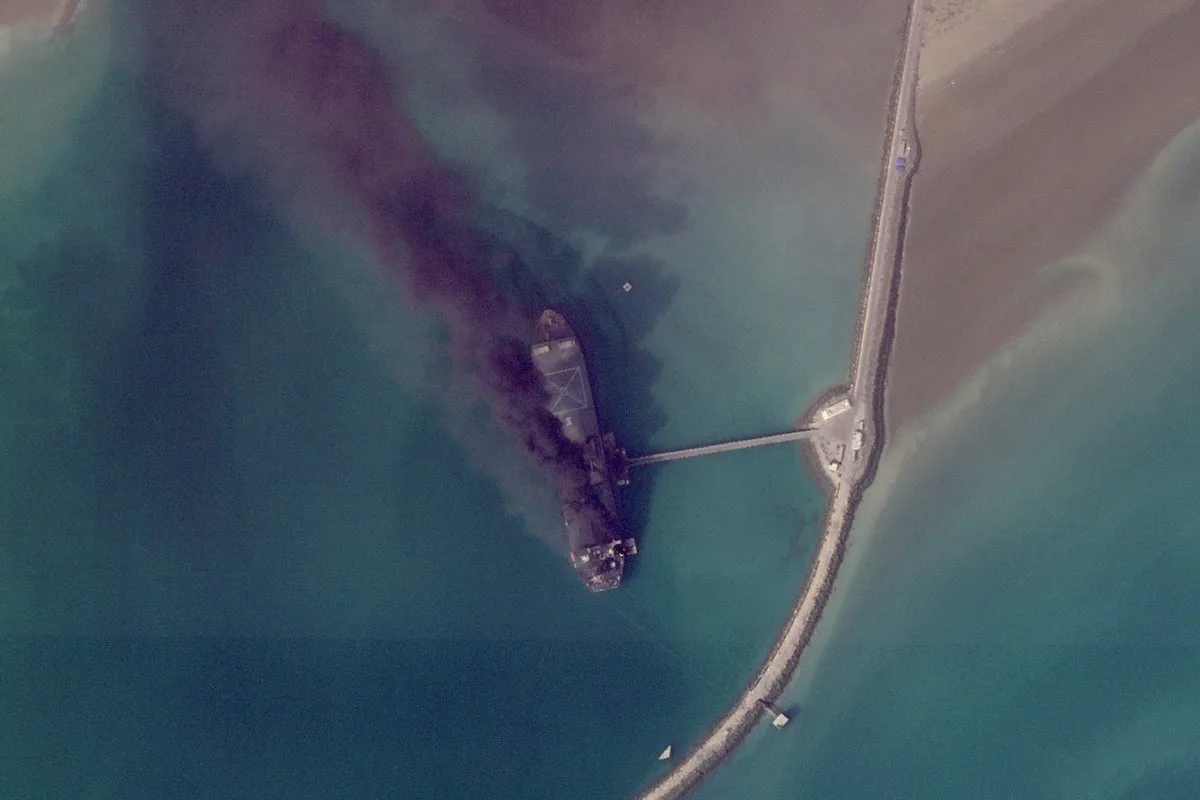
Newly released satellite imagery is providing a stark visual account of the widespread destruction caused by the ongoing conflict in Iran, revealing scenes of ships ablaze in a major military port and critical infrastructure on fire across the Middle East. The images, captured by firms like Planet Labs PBC and the U.S. Geological Survey, offer a rare glimpse into the toll of a war that began on February 28, 2026, where information has been tightly controlled, especially regarding damage inside closed military facilities.
Dramatic Scenes at Bandar Abbas Port
Some of the most compelling images come from Bandar Abbas, a key Iranian military port located adjacent to the strategically vital Strait of Hormuz, which connects the Persian Gulf to the Arabian Sea. High-resolution pictures taken on March 2, 2026, clearly show multiple vessels engulfed in flames following targeted attacks. The U.S. military's Central Command has acknowledged focusing on Iran's naval assets, claiming to have sunk or damaged over 100 Iranian vessels since the conflict erupted.
Impact on U.S. and Allied Bases
The satellite evidence extends beyond Iranian territory, highlighting significant damage to American and allied installations. In Bahrain, home to the U.S. Navy's 5th Fleet, a March 1 image reveals a major building destroyed and two radomes—geodesic domes protecting radar antennas—likely hit by Iranian missile and drone fire. Although the Navy has not provided a detailed damage assessment, Iran has repeatedly asserted attacks on this base, with online videos corroborating incoming fire.
Similarly, in Abu Dhabi, the capital of the United Arab Emirates, satellite images from March 3 show damage to two large hangar-like structures at France's Camp de la Paix naval base. This facility is situated near Zayed Port and the Cultural District, which includes prominent sites like the Louvre Abu Dhabi, underscoring the conflict's proximity to civilian and cultural areas.
Fires Rage at Key Transport Hubs
The U.S. Geological Survey's Landsat satellites have been instrumental in detecting major fires resulting from the hostilities. Imagery from Monday, March 16, 2026, captured a fire at Dubai International Airport, ignited when an Iranian drone strike set a fuel tanker ablaze. This incident at the world's busiest airport for international travel produced a plume of toxic black smoke, disrupting operations and raising safety concerns.
Another persistent fire was observed on the same day at Oman's southern port in Salalah, which came under suspected Iranian drone attack on March 11. Despite Tehran's denials of involvement in targeting Gulf Arab states, the fire has apparently been burning continuously since the assault, indicating sustained damage to regional infrastructure.
Information Control and Delayed Release
Planet Labs PBC, a San Francisco-based company utilized by media outlets including The Associated Press, has implemented a two-week delay on making its imagery public. This precaution stems from concerns that real-time data could be exploited by "adversarial actors" in the conflict. Meanwhile, other providers continue to publish lower-resolution images that still offer valuable insights into the war's progression.
The conflict has seen the U.S. and Israel striking a broad array of targets, such as leadership figures, military bases, missile sites, and positions held by Iran's Revolutionary Guard and its Basij volunteer force. In response, Iran has launched drone and missile attacks targeting Israel and nearby Gulf Arab nations, escalating tensions across the region.
As satellite images continue to emerge, they not only document the physical devastation but also highlight the challenges in accessing timely information during modern warfare, where closed facilities and strategic delays obscure the full extent of the damage.


