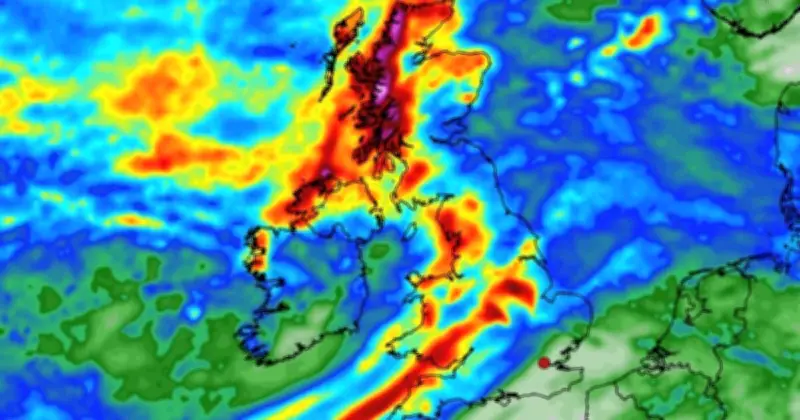
Britain's fifth heatwave is set to end as a 660-mile wall of rain moves in from the Scottish Highlands to Cornwall, threatening to drench 48 counties. The latest weather maps show the worst-hit areas could see 49mm of rainfall.
Hottest day of the year so far
Provisional figures suggest Thursday was the hottest day of the year so far, with temperatures exceeding 38C. The mercury reached 38.1C in Kew Gardens, west London, surpassing the previous record of 38C set on June 26.
However, dramatic WXCHARTS weather maps show a major shift in conditions, with heavy rain drenching nearly all of the country from 6am on Friday, August 21.
Rainfall forecasts
South Wales and Gwynedd are on track to bear the brunt of the weather front, with 7.55mm forecast to fall every hour. Gloucestershire, Oxfordshire, Wiltshire and large swathes of the east Midlands will see a maximum of 7mm of rain an hour.
The tip of Cornwall is forecast to receive around 4mm of rain, while large parts of the South West, Midlands and East Anglia are also expected to see rainfall, with levels ranging from 0.4mm to 2mm per hour.
By midday, the rain will have shifted towards northern England and Scotland, with the main area of rain looking set to fall on Yorkshire and the Humber, the North East and North West.
Accumulated rainfall by 6pm
By 6pm, south Wales is forecast to have received a whopping 49mm of rain, with Worcestershire and Gloucestershire not far behind with 46mm. Northwest Wales will have accumulated 31mm of rain whilst Devon and Cornwall will see up to 26mm, the maps suggest.
Parts of the Midlands could see up to 36mm of rainfall, while weather maps indicate that the Scottish Highlands and Argyll and Bute could receive as much as 84mm of rainfall. Meanwhile, Aberdeenshire will see 47mm, the maps show.
Wales will continue to see patches of rain, with the maps forecasting large swathes of Scotland will see up to 3mm of rain fall an hour.
Met Office outlook
The Met Office weather forecast for August 18-27 reads: "A rather more changeable spell of weather through the mid to latter part of August, with Atlantic frontal systems bringing some rain or showers at times to the UK.
"The heavier and more reliable rainfall is more likely to be in parts of the west and northwest, but it is possible that some southern and eastern areas will see rain at times too. Later in the period high pressure may have more of an influence with drier conditions returning for many areas. Temperatures are likely to remain above average overall, with the possibility of further hot weather developing."
The 49 UK counties forecast rain are: Cheshire, Staffordshire, Shropshire, Derbyshire, Nottinghamshire, Leicestershire, Lincolnshire, Yorkshire, Lancashire, Greater Manchester, Warwickshire, Worcestershire, Herefordshire, Northamptonshire, Cambridgeshire, Bedfordshire, Rutland, North Yorkshire, Durham, Northumberland, Devon, Cornwall, Somerset, Dorset, Wiltshire, Hampshire, Oxfordshire, Gwynedd, Conwy, Wrexham, Powys, Ceredigion, Pembrokeshire, Carmarthenshire, Swansea, Cardiff, Bridgend, Merthyr Tydfil, Caerphilly, Blaenau Gwent, Monmouthshire, Dumfries and Galloway, Ayrshire, Lanarkshire, Argyll and Bute, Glasgow, Stirling, and Scottish Highlands.