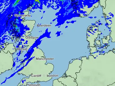
The Met Office has warned that the tail end of Hurricane Erin could bring heavy wind, rain and “very large waves” to the UK next week, potentially ending the dry spell and providing a wet and windy conclusion to the summer.
Erin, currently a category 2 storm moving eastwards across the North Atlantic, is expected to affect the UK from the middle of next week. Met Office meteorologist Tom Morgan noted that it is “too early for specific details about which parts of the country will see the windiest and wettest weather,” but a noticeable drop in temperatures is anticipated.
“What we can say is that it will gradually turn less hot and be more generally changeable,” said Morgan. Thundery showers are possible during parts of next week, with Thursday and Friday more likely to see stormy conditions. The rain could spread across the UK, bringing an end to the recent dry spell.

Morgan added: “Britain is likely to see some very large waves. Ex-hurricane Erin will bring quite a large swell in the sea, so we could potentially see waves of 4 to 5 metres in height for the Western Isles of Scotland and Ireland. For holidaymakers going to the coast, that could prove quite a hazard.”
Despite the forecast, Morgan stressed that the unsettled weather is still “a long way in the future,” with sunshine expected this August bank holiday weekend for England, Wales and Northern Ireland.
Hurricane Erin has weakened from a category 5 storm as it moved along the east coast of North America, but it has already caused significant disruption, including the evacuation of over 2,000 people in North Carolina and the rescue of at least 60 swimmers from rip currents at Wrightsville Beach on Monday.