West Ireland's newly designated Joyce Country and Western Lakes Unesco Geopark in Galway and Mayo celebrates a 700-million-year geological history that has produced a unique terrain and rich cultural heritage. According to Dr. Benjamin Thébaudeau, geologist for the geopark, the massive system of limestone springs and caves is the engine driving this landscape, much like an underground train network powers a city.
A Landscape of Hidden Waters
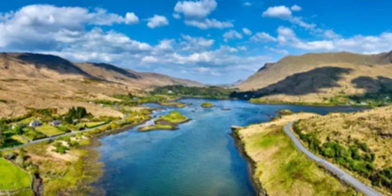
This is a place where rivers disappear into limestone fissures and subterranean lakes, and where roads twist through drowned valleys beneath mountains shaped by fire and ice. The dreamy, lush landscape famously drew Hollywood to the village of Cong for The Quiet Man in 1952. Cong is effectively an inland island between Lough Mask and Lough Corrib, taking its name from the Irish for 'narrows,' a reference to its tight, water-bound geography and the concentration of springs that rise and fall invisibly beneath the surface.
Water is everywhere and rarely still. It drains from Lough Mask through swallow holes before travelling unseen for miles through limestone fissures beneath Cong, eventually forcing its way back to the surface as cold springs around the village. Dr. Thébaudeau points out the Hatchery, where springs bubble up in the middle of channels, noting the current flowing in opposite directions.

Cultural and Linguistic Layers
The geopark's character is not only defined by its karst terrain and glacial valleys. At its core sits a living Gaeltacht where Irish is still spoken daily, embedded in place names, local conversation, and nightly sessions at Burke's Bar in nearby Clonbur. The language runs through the landscape as another ingrained system alongside rock, water, and soil.
The Augustinian abbey at Cong was founded under Gaelic royal patronage, yet its surviving stone arches reflect the deep architectural imprint left by later Norman reconstruction. In the 12th century, Ruaidrí Ua Conchobair, the last high king of Ireland, spent his final 15 years within these walls. Centuries later, the abbey was suppressed, and Sir Richard Bingham turned Ashford Castle into a menacing administrative hub. The castle was bought in 1852 by the Guinness family, who transformed the medieval ruins into a grand Victorian hunting lodge.
The Quiet Man Legacy
At The Quiet Man Museum, curator Lisa Collins spoke of the enduring pull of John Ford's film. Honeymooning visitors still arrive dressed as Sean Thornton and Mary Kate Danaher, stepping into a version of Ireland that has long outlived the production. The museum has been designated a Treasure of European Film Culture by the European Film Academy, with plans to mark the 75th anniversary of the film in Cong next year.
Among the exhibits is the fishing rod used by the village priest during filming on the River Cong. In the celebrated scene, Mary Kate speaks in Irish to Father Lonergan as he casts for a legendary salmon, explaining that she has refused to consummate the marriage while her husband sleeps in a 'mála codlata' (sleeping bag). The language allowed the exchange to move beneath the radar of 1952 censorship, yet was fully understood within the Gaeltacht.
Legends and Geology
The subterranean world becomes tangible at the Pigeon Hole cave system. The entrance drops steeply into the limestone, leading into a narrow chasm where a shallow underground river moves through darkness. Here, the legend of the White Trout of Cong tells of a young woman who vanished after her lover's murder, only for a white trout to appear. Dr. Thébaudeau notes that fish living in darkness can lose pigmentation over time, so the legend may have a basis in observation.
Fishing remains central here, both as practice and inheritance. Near Ashford Castle, a salmon hatchery attempts to support declining wild populations. However, climate change, warming seas, and mounting pressure on river systems are affecting wild Atlantic salmon. Trout remain more resilient, spending their lives within local waters.

Historical Depths
Further inland at Carnacon, the ruins of Moore Hall estate rise above Lough Carra. One of the few Catholic-owned landed estates, the house became associated with the great famine-era MP George Henry Moore. Today, it sits partially collapsed since its destruction during the civil war, though the surrounding woods have absorbed rather than erased it.
Not far away in Ballinrobe, Captain Charles Boycott became the focus of organized worker resistance during the land war in 1879. His name entered the global vocabulary as a verb, detached from its local origins yet still rooted in this terrain of contested land and memory.
Connemara and the Fjord
Further west in Connemara, the landscape shifts dramatically as it reaches towards the Atlantic. At Killary Fjord, the land suddenly opens into deep water, a glacial incision dividing Connemara from Mayo. The fjord exposes geology directly, revealing the force with which ice once carved through the earth.
To the south, Kylemore Abbey appears against the hillside above Pollacappul Lough. Built first as a private residence before becoming a Benedictine monastery, it carries another layered story of adaptation and loss, with the landscape mirrored back perfectly in the still water.
Across these places, patterns continue to repeat in altered forms. Water disappears underground before resurfacing elsewhere. Estates become ruins. Ruins become woodland. Language carries meanings beneath meanings. Stories survive by changing shape.
Returning to Cong, one gains a better understanding of how it forms part of a much larger system of geological flow, historical pressure, and cultural inheritance. What holds this region together is not stillness, but movement beneath the surface. Above Lough Nafooey, not far from the hairpin bends etched into the volcanic ash surface of Aill Dubh, a cuckoo's call crosses the hills, marking time in a landscape that never quite repeats itself in the same way twice.