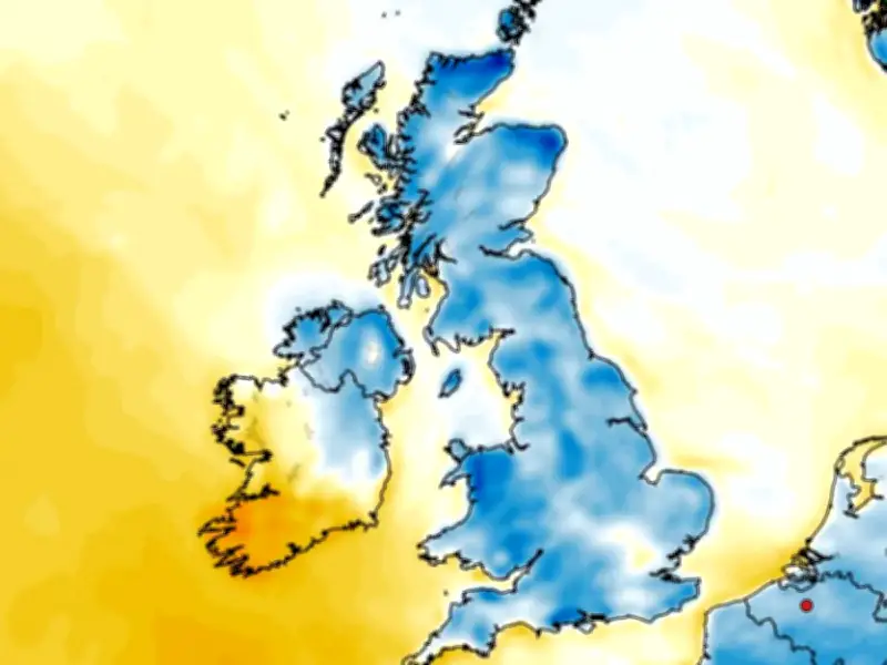
Scotland could see its first significant snowfall of the season this month, with weather models showing snow possible across parts of the country towards the middle of October, particularly over higher ground. Around 5cm, or roughly two inches, could fall in some areas.
While snowfall at higher elevations is not unusual in Scotland during October, it would mark the first major snowfall of the season and could provide an early reminder that winter is on its way.
El Niño and the polar vortex
The prospect of wintry weather comes as forecasters continue to monitor the impact of the record-breaking El Niño weather pattern. The Met Office has said El Niño could contribute to a weakening of the polar vortex, which may in turn lead to Sudden Stratospheric Warming (SSW).
The process can be associated with major changes in weather patterns and has previously been linked to cold snaps across the UK. A similar atmospheric set-up was associated with the infamous 'Beast from the East' in 2018, when bitterly cold air and heavy snow caused widespread disruption.
But while the possibility of a colder spell later in the year remains, the latest forecasts suggest Scotland is unlikely to face an early widespread Arctic blast this month.
BBC Weather forecast for late October
BBC Weather forecasters have now issued their latest assessment of conditions from October 19 to November 1, including what Scotland can expect as we head towards the end of the month. The forecast suggests Scotland is likely to be wetter than many parts of the UK during the period, with "occasional frontal systems" expected to bring rain to northern areas.
Most of the UK is expected to see "drier than normal conditions", particularly across southern parts, meaning Scotland could see a noticeably different pattern. There is also the potential for some chilly conditions, with BBC Weather warning of "chilly and foggy nights" at times.
However, temperatures are not currently expected to fall significantly below average. Instead, BBC Weather says temperatures are more likely to be "close to or a little above normal than below" overall.
The forecast adds: "There is no sign yet of any set up that might lead to a risk of an early cold Arctic outbreak.
"There is a chance of an alternative outcome where high pressure shifts farther away, allowing low pressure systems closer to the UK, with a wetter and windier but mild outcome."
That means there is currently no strong signal for the type of widespread snow and freezing temperatures seen during the 'Beast from the East'. However, conditions across Scotland could still turn colder at times, particularly in higher and more exposed areas.
Met Office outlook into November
The Met Office is also predicting changeable conditions as October draws to a close and November begins. Its forecast for October 21 to November 4 says "occasional colder interludes will be possible at times", although temperatures "are likely to be near or a little above average for the period as a whole".
It expects the remainder of October and the beginning of November to be dominated by a changeable weather pattern, with areas of low pressure regularly moving close to the UK from the North Atlantic. These will be interspersed with occasional areas of high pressure.
The Met Office says: "The remainder of October and into early November will probably maintain a changeable pattern overall, with areas of low pressure often passing close to the UK from the North Atlantic, interspersed by occasional ridges of high pressure.
"As such, showers or longer spells of rain are likely at times, with the wettest and windiest weather typically in the west and northwest, driest conditions more favoured in sheltered southern and eastern parts.
"A trend to more widely unsettled conditions is possible into November."
For Scotland, that means western and north-western areas are likely to bear the brunt of the wetter and windier conditions, while some eastern and southern areas could see drier spells.
Major snow spell prospects
The latest forecasts do not currently point to a repeat of the 'Beast from the East' this month. However, forecasters will continue to watch the wider weather pattern as the year progresses, particularly because of the potential influence of El Niño on the polar vortex.
A weakening polar vortex can contribute to Sudden Stratospheric Warming, which can disrupt the circulation of cold air around the Arctic. Depending on how the atmosphere responds, this can increase the potential for colder air to move south towards the UK.
It does not mean that a major snow event is guaranteed, and any impact on Scotland would depend on how the atmospheric pattern develops. For now, the latest outlook points towards a broadly mild and unsettled end to October, with Scotland among the areas most likely to see rain and strong winds. But higher parts of the country could still see some early-season snow, and forecasters will be watching closely for any signs of a more significant cold spell developing.