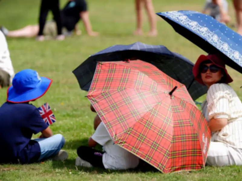
The Met Office has issued a red alert urging Brits to protect themselves from high UV levels as temperatures are set to reach 34°C this weekend. The UK Health Security Agency (UKHSA) has also issued an alert across East Midlands, South East, South West, East of England, and London from 12 PM on Saturday, July 4, until 5 PM on Wednesday, July 8.
UKHSA Warning: Health Impacts Expected
The UKHSA warns that due to forecast temperatures, the UK is likely to see minor impacts across health and social care services. These include increased use of healthcare services by vulnerable people, greater risk to life for vulnerable individuals, increased potential for indoor environments to become very warm, and a rise in water-related incidents, including risks from cold-water shock and drowning.
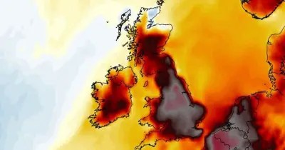
Met Office: UV Levels High Despite Cloud Cover
Although large parts of the country will be covered by cloud over the weekend, the Met Office has warned that UV levels will still be 'high' or even 'very high'. In a post on X, the Met Office wrote: "Although there is some cloud in the north this weekend, UV will still be in the moderate to high range in places. Further south, with more sunny spells, they will climb to high, or even very high. Make sure you have your sun cream close by."

The post shows UV levels reaching eight in London and Exeter, six in Leeds, Edinburgh, and Lerwick. In Greater Manchester, UV levels will reach six, which is considered 'high'.
Weekend Weather Breakdown
According to the Met Office, Saturday will begin with plenty of cloud across northern and western areas, accompanied by outbreaks of rain. These may extend as far south as north Wales and northwest England at times, although amounts are generally expected to be non-impactful. The most persistent and heaviest rain will be focused across western Scotland, particularly the West Highlands, where rainfall will be heavy at times. Eastern Scotland is expected to fare better, benefiting from drier and brighter conditions due to a rain-shadow effect.
Further south, variable cloud will allow for spells of sunshine and a warm afternoon. Temperatures will widely reach the low to mid-20s, with highs of around 29°C possible in the south-east of England. Although temperatures will be climbing, most locations are unlikely to meet official heatwave thresholds on Saturday. However, conditions will continue to warm as the weekend progresses.
By Sunday, the contrast across the UK becomes even more pronounced. Widespread rain is expected across Scotland, with outbreaks also affecting parts of Northern England, including the Pennines and Lake District, as well as Northern Ireland. Central and north-west Scotland are likely to experience a cloudy, windy, and wet start to the day, while western Scotland continues to see the most persistent rainfall. The region could accumulate in excess of 75mm of rain by the end of the weekend.
Further south, conditions will be markedly different. Lighter winds, longer spells of sunshine, and generally dry weather will help temperatures rise a little higher than on Saturday. Across the Midlands, East Anglia, and the south-east of England, temperatures are expected to reach the mid to high 20s. For some areas, these temperatures could be sufficient to meet local heatwave criteria.
Next Week: High Pressure Dominates
Next week, the Met Office says that high pressure is expected to become increasingly dominant. Once the remaining weather systems clear through early in the week, frontal systems should become confined mainly to the far north-west of Scotland, with much of the rest of the UK turning increasingly dry and bright. Temperatures are expected to rise, with highs reaching the upper 20s and locally the low 30s across parts of the Midlands, East Anglia, and south-east England.
Although parts of the UK will hit their heatwave thresholds next week, the Met Office says it is not expected to be a repeat of the late-June heatwave. The Met Office explains: "The position of the high-pressure system means the UK will avoid the exceptionally hot continental air that fuelled the recent record-breaking temperatures across western Europe. As a result, temperatures are likely to remain in the high 20s or low 30s rather than the mid to high 30s, and humidity levels should be noticeably lower."